
 ,
, 
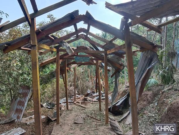
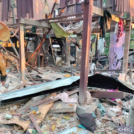
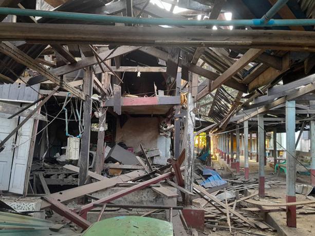
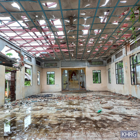
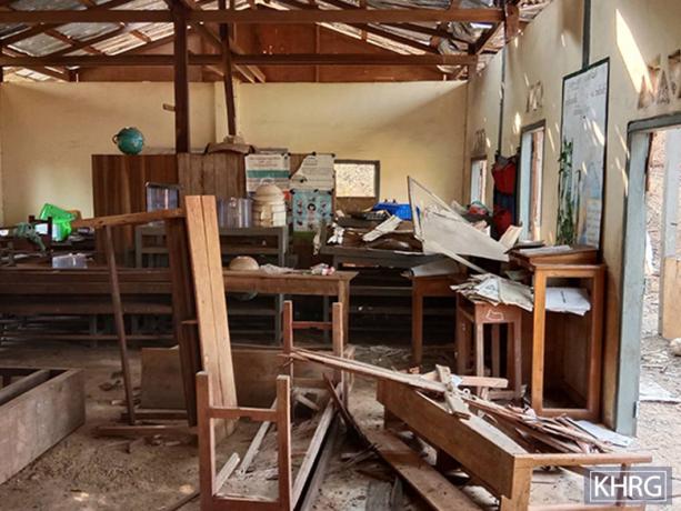
These two photos were taken in January 2025 in Bb--- village, Min Saw village tract[5], Bilin Township, Doo Tha Htoo District. On January 16th 2025, a State Administration Council (SAC)[6] kamikaze drone, also known as a suicide drone, crashed into the school in Bb--- village, damaging it. No one was harmed, as the drone strike happened after school hours. After the air strike, students could not attend school because villagers were too afraid. This caused the school to close. The school had been supported by the Karen Education and Culture Department (KECD)[7] since the 2021 coup. The photo on the left displays the damaged metal roof and ceiling of the school. The photo on the right displays the shattered windows and damage to the ceiling of the school.[8] [Photos: KHRG]
Photo Set: Burma Army air strikes resulting in casualties, destruction, displacement, and contamination in 2025
Since 2021, the Burma military regime[1] has increasingly used air strikes in Southeast Burma, resulting in widespread civilian deaths and injuries, destruction, and displacement. Based on KHRG documentation, in 2025, the Burma Army used different types of weapons, including machine guns, mortars, and various bombs, when conducting deadly air strikes on communities in the seven districts of locally-defined Karen State[2]: Doo Tha Htoo (Thaton), Taw Oo (Toungoo), Kler Lwee Htoo (Nyaunglebin), Mergui-Tavoy, Mu Traw (Hpapun), Dooplaya, and Hpa-an districts.[3] Air attacks were conducted with or without active fighting near villages, without warning or other precautionary measures before the attack.[4] Often, air strikes followed air reconnaissance. A high number of air strikes impacted community buildings, such as schools, monastery compounds, and churches, which are often clearly identifiable from the air, as well as villagers’ homes, farms, and plantations.
This Photo Set includes 83 photos (selected from a total of 3,662 photographs received in 2025), providing evidence of impacts faced by local villagers in the aftermath of Burma Army air strikes in Southeast Burma. 74 of the included photographs were taken by local community members trained by KHRG to monitor human rights conditions in their areas, and nine were taken by local villagers and authorities. The photos show casualties, destruction, displacement, and the different types of weapons used by the Burma Army during air attacks. The names of the victims, their photos, and the exact locations are censored for security and sensitivity reasons.
Further background reading on the situation of air strikes in Southeast Burma/Myanmar can be found in the following KHRG reports:
 ,
, 
These photos were taken in January 2025 on a rubber plantation near Aa--- village, Ha T'Reh village tract, Hpa-an Township, Doo Tha Htoo District. On January 22nd 2025, an SAC fighter jet dropped two 500-pound bombs on Aa--- village area. The bombs landed and exploded in a rubber plantation near Aa--- village, damaging the plantation, as shown in the photos. The plantation is owned by a local villager from Aa--- village. [Photos: KHRG]
Photo Set: Burma Army air strikes resulting in casualties, destruction, displacement, and contamination in 2025
Since 2021, the Burma military regime[1] has increasingly used air strikes in Southeast Burma, resulting in widespread civilian deaths and injuries, destruction, and displacement. Based on KHRG documentation, in 2025, the Burma Army used different types of weapons, including machine guns, mortars, and various bombs, when conducting deadly air strikes on communities in the seven districts of locally-defined Karen State[2]: Doo Tha Htoo (Thaton), Taw Oo (Toungoo), Kler Lwee Htoo (Nyaunglebin), Mergui-Tavoy, Mu Traw (Hpapun), Dooplaya, and Hpa-an districts.[3] Air attacks were conducted with or without active fighting near villages, without warning or other precautionary measures before the attack.[4] Often, air strikes followed air reconnaissance. A high number of air strikes impacted community buildings, such as schools, monastery compounds, and churches, which are often clearly identifiable from the air, as well as villagers’ homes, farms, and plantations.
This Photo Set includes 83 photos (selected from a total of 3,662 photographs received in 2025), providing evidence of impacts faced by local villagers in the aftermath of Burma Army air strikes in Southeast Burma. 74 of the included photographs were taken by local community members trained by KHRG to monitor human rights conditions in their areas, and nine were taken by local villagers and authorities. The photos show casualties, destruction, displacement, and the different types of weapons used by the Burma Army during air attacks. The names of the victims, their photos, and the exact locations are censored for security and sensitivity reasons.
Further background reading on the situation of air strikes in Southeast Burma/Myanmar can be found in the following KHRG reports:
 ,
, 
The photos were taken in January 2025 at Cc--- village, Ta Aoo Hkee village tract, Bilin Township, Doo Tha Htoo District. On January 31st 2025, six SAC kamikaze drones crashed into Cc--- village. Three kamikaze drones exploded inside the village, damaging a monastery. The other three landed in farms outside of the village and did not explode. As the drone strike caused fear among the villagers, some villagers slept in huts outside of the village during the nighttime and only returned to the village at sunrise. The photo on the left shows two kamikaze drones that were found by the villagers. One drone landed inside the village, and the other landed outside the village. The photo on the right shows an SAC drone after it crashed and exploded on a monastery’s grounds, near a school.[9] [Photos: KHRG]
Photo Set: Burma Army air strikes resulting in casualties, destruction, displacement, and contamination in 2025
Since 2021, the Burma military regime[1] has increasingly used air strikes in Southeast Burma, resulting in widespread civilian deaths and injuries, destruction, and displacement. Based on KHRG documentation, in 2025, the Burma Army used different types of weapons, including machine guns, mortars, and various bombs, when conducting deadly air strikes on communities in the seven districts of locally-defined Karen State[2]: Doo Tha Htoo (Thaton), Taw Oo (Toungoo), Kler Lwee Htoo (Nyaunglebin), Mergui-Tavoy, Mu Traw (Hpapun), Dooplaya, and Hpa-an districts.[3] Air attacks were conducted with or without active fighting near villages, without warning or other precautionary measures before the attack.[4] Often, air strikes followed air reconnaissance. A high number of air strikes impacted community buildings, such as schools, monastery compounds, and churches, which are often clearly identifiable from the air, as well as villagers’ homes, farms, and plantations.
This Photo Set includes 83 photos (selected from a total of 3,662 photographs received in 2025), providing evidence of impacts faced by local villagers in the aftermath of Burma Army air strikes in Southeast Burma. 74 of the included photographs were taken by local community members trained by KHRG to monitor human rights conditions in their areas, and nine were taken by local villagers and authorities. The photos show casualties, destruction, displacement, and the different types of weapons used by the Burma Army during air attacks. The names of the victims, their photos, and the exact locations are censored for security and sensitivity reasons.
Further background reading on the situation of air strikes in Southeast Burma/Myanmar can be found in the following KHRG reports:
 ,
, 
These photos were taken in February 2025 at Dd--- village, Ah Su Chaung village tract, Bilin Township, Doo Tha Htoo District. On February 7th 2025, an SAC fighter jet dropped seven bombs on Ah Su Chaung village tract. One bomb landed at the entrance of a KECD-supported school in Dd--- village, damaging the teachers’ boarding house and a school building. Two bombs landed in the village area, but as no villagers were living there, the bombs did not cause injuries. The four remaining bombs landed outside of Dd--- village and caused no damage or injuries. The photos show damage caused by the bomb that landed near the school in Dd--- village.[10] [Photos: KHRG]
Photo Set: Burma Army air strikes resulting in casualties, destruction, displacement, and contamination in 2025
Since 2021, the Burma military regime[1] has increasingly used air strikes in Southeast Burma, resulting in widespread civilian deaths and injuries, destruction, and displacement. Based on KHRG documentation, in 2025, the Burma Army used different types of weapons, including machine guns, mortars, and various bombs, when conducting deadly air strikes on communities in the seven districts of locally-defined Karen State[2]: Doo Tha Htoo (Thaton), Taw Oo (Toungoo), Kler Lwee Htoo (Nyaunglebin), Mergui-Tavoy, Mu Traw (Hpapun), Dooplaya, and Hpa-an districts.[3] Air attacks were conducted with or without active fighting near villages, without warning or other precautionary measures before the attack.[4] Often, air strikes followed air reconnaissance. A high number of air strikes impacted community buildings, such as schools, monastery compounds, and churches, which are often clearly identifiable from the air, as well as villagers’ homes, farms, and plantations.
This Photo Set includes 83 photos (selected from a total of 3,662 photographs received in 2025), providing evidence of impacts faced by local villagers in the aftermath of Burma Army air strikes in Southeast Burma. 74 of the included photographs were taken by local community members trained by KHRG to monitor human rights conditions in their areas, and nine were taken by local villagers and authorities. The photos show casualties, destruction, displacement, and the different types of weapons used by the Burma Army during air attacks. The names of the victims, their photos, and the exact locations are censored for security and sensitivity reasons.
Further background reading on the situation of air strikes in Southeast Burma/Myanmar can be found in the following KHRG reports:
 ,
, 
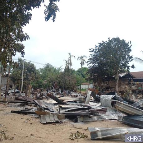
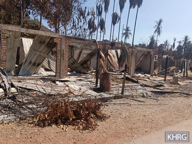
These photos were taken in February 2025 at Bb--- village, Min Saw village tract, Bilin Township, Doo Tha Htoo District. On February 9th 2025, at around 12:47 pm, an SAC fighter jet dropped two 500-pound bombs on Bb--- village, severely damaging a monastery building and a palm plantation in the monastery’s compound, injuring two monks, and destroying five villagers’ houses. The photo on the left shows the severe damage to the monastery building caused by the bombs. The photo on the right displays a villager’s house, which was damaged by the bombs. Nobody else was injured because all the villagers in Bb--- village had fled after the SAC attacks on the village in January 2025. [Photos: KHRG]
Photo Set: Burma Army air strikes resulting in casualties, destruction, displacement, and contamination in 2025
Since 2021, the Burma military regime[1] has increasingly used air strikes in Southeast Burma, resulting in widespread civilian deaths and injuries, destruction, and displacement. Based on KHRG documentation, in 2025, the Burma Army used different types of weapons, including machine guns, mortars, and various bombs, when conducting deadly air strikes on communities in the seven districts of locally-defined Karen State[2]: Doo Tha Htoo (Thaton), Taw Oo (Toungoo), Kler Lwee Htoo (Nyaunglebin), Mergui-Tavoy, Mu Traw (Hpapun), Dooplaya, and Hpa-an districts.[3] Air attacks were conducted with or without active fighting near villages, without warning or other precautionary measures before the attack.[4] Often, air strikes followed air reconnaissance. A high number of air strikes impacted community buildings, such as schools, monastery compounds, and churches, which are often clearly identifiable from the air, as well as villagers’ homes, farms, and plantations.
This Photo Set includes 83 photos (selected from a total of 3,662 photographs received in 2025), providing evidence of impacts faced by local villagers in the aftermath of Burma Army air strikes in Southeast Burma. 74 of the included photographs were taken by local community members trained by KHRG to monitor human rights conditions in their areas, and nine were taken by local villagers and authorities. The photos show casualties, destruction, displacement, and the different types of weapons used by the Burma Army during air attacks. The names of the victims, their photos, and the exact locations are censored for security and sensitivity reasons.
Further background reading on the situation of air strikes in Southeast Burma/Myanmar can be found in the following KHRG reports:
 ,
, 
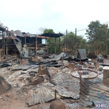
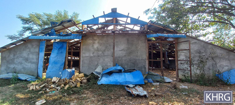
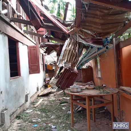
These photos were taken in April 2025 in Ee--- village, Htee Hpah Doh Hta village tract, Bilin Township, Doo Tha Htoo District. On February 13th 2025, an SAC fighter jet dropped two 500-pound bombs on Ee--- village, destroying a church and five villagers’ houses, and damaging 22 villagers’ houses. After the first bomb landed in the church area, villagers fled from the village. Therefore, no villagers were killed or injured. The photo on the left shows the destroyed church, and the photo on the right shows a villager’s destroyed house. [Photos: KHRG]
Photo Set: Burma Army air strikes resulting in casualties, destruction, displacement, and contamination in 2025
Since 2021, the Burma military regime[1] has increasingly used air strikes in Southeast Burma, resulting in widespread civilian deaths and injuries, destruction, and displacement. Based on KHRG documentation, in 2025, the Burma Army used different types of weapons, including machine guns, mortars, and various bombs, when conducting deadly air strikes on communities in the seven districts of locally-defined Karen State[2]: Doo Tha Htoo (Thaton), Taw Oo (Toungoo), Kler Lwee Htoo (Nyaunglebin), Mergui-Tavoy, Mu Traw (Hpapun), Dooplaya, and Hpa-an districts.[3] Air attacks were conducted with or without active fighting near villages, without warning or other precautionary measures before the attack.[4] Often, air strikes followed air reconnaissance. A high number of air strikes impacted community buildings, such as schools, monastery compounds, and churches, which are often clearly identifiable from the air, as well as villagers’ homes, farms, and plantations.
This Photo Set includes 83 photos (selected from a total of 3,662 photographs received in 2025), providing evidence of impacts faced by local villagers in the aftermath of Burma Army air strikes in Southeast Burma. 74 of the included photographs were taken by local community members trained by KHRG to monitor human rights conditions in their areas, and nine were taken by local villagers and authorities. The photos show casualties, destruction, displacement, and the different types of weapons used by the Burma Army during air attacks. The names of the victims, their photos, and the exact locations are censored for security and sensitivity reasons.
Further background reading on the situation of air strikes in Southeast Burma/Myanmar can be found in the following KHRG reports:
 ,
, 
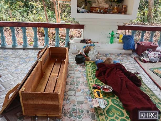
These photos were taken in April 2025 in a monastery’s compound in Ff--- village, Min Saw village tract, Bilin Township, Doo Tha Htoo District. On April 19th 2025, when monks were having lunch, an SAC fighter jet dropped two 500-pound bombs on a monastery in Ff--- village, killing one monk and two villagers, and injuring six other monks and four villagers. The monastery was also destroyed. The photo on the left shows a monk, who was killed by the SAC air strike, being prepared for burial. The photo on the right shows the destroyed monastery building in Ff--- village.[11] [Photos: KHRG]
Photo Set: Burma Army air strikes resulting in casualties, destruction, displacement, and contamination in 2025
Since 2021, the Burma military regime[1] has increasingly used air strikes in Southeast Burma, resulting in widespread civilian deaths and injuries, destruction, and displacement. Based on KHRG documentation, in 2025, the Burma Army used different types of weapons, including machine guns, mortars, and various bombs, when conducting deadly air strikes on communities in the seven districts of locally-defined Karen State[2]: Doo Tha Htoo (Thaton), Taw Oo (Toungoo), Kler Lwee Htoo (Nyaunglebin), Mergui-Tavoy, Mu Traw (Hpapun), Dooplaya, and Hpa-an districts.[3] Air attacks were conducted with or without active fighting near villages, without warning or other precautionary measures before the attack.[4] Often, air strikes followed air reconnaissance. A high number of air strikes impacted community buildings, such as schools, monastery compounds, and churches, which are often clearly identifiable from the air, as well as villagers’ homes, farms, and plantations.
This Photo Set includes 83 photos (selected from a total of 3,662 photographs received in 2025), providing evidence of impacts faced by local villagers in the aftermath of Burma Army air strikes in Southeast Burma. 74 of the included photographs were taken by local community members trained by KHRG to monitor human rights conditions in their areas, and nine were taken by local villagers and authorities. The photos show casualties, destruction, displacement, and the different types of weapons used by the Burma Army during air attacks. The names of the victims, their photos, and the exact locations are censored for security and sensitivity reasons.
Further background reading on the situation of air strikes in Southeast Burma/Myanmar can be found in the following KHRG reports:
 ,
, 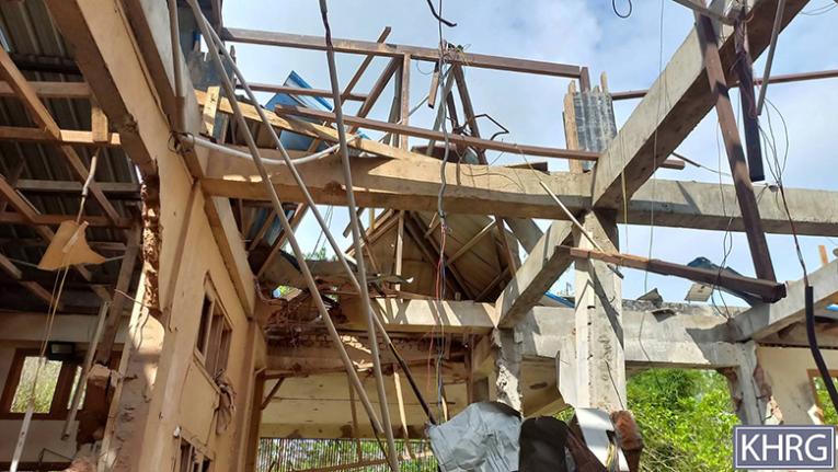
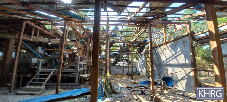
These photos were taken in May 2025 in Gg--- village, Ha T'Reh village tract, Hpa-an Township, Doo Tha Htoo District. On May 4th 2025, at around midnight, an SAC fighter jet dropped two bombs in Gg--- village (also known as Hh---), destroying a 16-bed hospital. After the SAC conducted an air strike on Gg--- hospital, villagers were unable to access healthcare in the village. This hospital was administered by the Karen Department of Health and Welfare (KDHW)[12]. The villagers and healthcare workers had temporarily fled before the incident, as they had been warned by local Karen National Union (KNU)[13] leaders about a possible SAC attack. As a result, no one was injured. These photos show a hospital that was destroyed after an SAC fighter jet conducted air strikes on Gg--- village.[14] [Photos: KHRG]
Photo Set: Burma Army air strikes resulting in casualties, destruction, displacement, and contamination in 2025
Since 2021, the Burma military regime[1] has increasingly used air strikes in Southeast Burma, resulting in widespread civilian deaths and injuries, destruction, and displacement. Based on KHRG documentation, in 2025, the Burma Army used different types of weapons, including machine guns, mortars, and various bombs, when conducting deadly air strikes on communities in the seven districts of locally-defined Karen State[2]: Doo Tha Htoo (Thaton), Taw Oo (Toungoo), Kler Lwee Htoo (Nyaunglebin), Mergui-Tavoy, Mu Traw (Hpapun), Dooplaya, and Hpa-an districts.[3] Air attacks were conducted with or without active fighting near villages, without warning or other precautionary measures before the attack.[4] Often, air strikes followed air reconnaissance. A high number of air strikes impacted community buildings, such as schools, monastery compounds, and churches, which are often clearly identifiable from the air, as well as villagers’ homes, farms, and plantations.
This Photo Set includes 83 photos (selected from a total of 3,662 photographs received in 2025), providing evidence of impacts faced by local villagers in the aftermath of Burma Army air strikes in Southeast Burma. 74 of the included photographs were taken by local community members trained by KHRG to monitor human rights conditions in their areas, and nine were taken by local villagers and authorities. The photos show casualties, destruction, displacement, and the different types of weapons used by the Burma Army during air attacks. The names of the victims, their photos, and the exact locations are censored for security and sensitivity reasons.
Further background reading on the situation of air strikes in Southeast Burma/Myanmar can be found in the following KHRG reports:
 ,
,  ,
, 
These photos were taken in May 2025 in Jj--- village, Win Kan village tract, Kyeh Htoh Township, Doo Tha Htoo District. On May 10th 2025, at 4 pm, an SAC Y-12 aircraft dropped five bombs onto Jj--- village. Four villagers' houses were burned, and two villagers' houses were damaged by the air strike. In addition, an 18-year-old villager named Saw[15] A--- and a 31-year-old villager named Saw B--- were injured by the shrapnel from the bomb explosion. After the incident, villagers from Jj--- village and other villages nearby fled from their villages. The photos show villagers’ houses in Jj--- village destroyed by the SAC air strike. [Photos: KHRG]
Photo Set: Burma Army air strikes resulting in casualties, destruction, displacement, and contamination in 2025
Since 2021, the Burma military regime[1] has increasingly used air strikes in Southeast Burma, resulting in widespread civilian deaths and injuries, destruction, and displacement. Based on KHRG documentation, in 2025, the Burma Army used different types of weapons, including machine guns, mortars, and various bombs, when conducting deadly air strikes on communities in the seven districts of locally-defined Karen State[2]: Doo Tha Htoo (Thaton), Taw Oo (Toungoo), Kler Lwee Htoo (Nyaunglebin), Mergui-Tavoy, Mu Traw (Hpapun), Dooplaya, and Hpa-an districts.[3] Air attacks were conducted with or without active fighting near villages, without warning or other precautionary measures before the attack.[4] Often, air strikes followed air reconnaissance. A high number of air strikes impacted community buildings, such as schools, monastery compounds, and churches, which are often clearly identifiable from the air, as well as villagers’ homes, farms, and plantations.
This Photo Set includes 83 photos (selected from a total of 3,662 photographs received in 2025), providing evidence of impacts faced by local villagers in the aftermath of Burma Army air strikes in Southeast Burma. 74 of the included photographs were taken by local community members trained by KHRG to monitor human rights conditions in their areas, and nine were taken by local villagers and authorities. The photos show casualties, destruction, displacement, and the different types of weapons used by the Burma Army during air attacks. The names of the victims, their photos, and the exact locations are censored for security and sensitivity reasons.
Further background reading on the situation of air strikes in Southeast Burma/Myanmar can be found in the following KHRG reports:
 ,
, 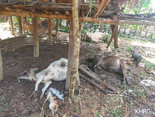
These photos were taken in October 2025 in Ii--- village, Yoh Klah village tract, Bilin Township, Doo Tha Htoo District. On October 9th 2025, at around 8 pm, a Burma Army aircraft dropped two 500-pound bombs on Ii--- village. While one of the bombs did not explode, the other bomb exploded, killing five children and injuring nine villagers, including two children. All of the victims were in their houses preparing to go to bed when the air strike happened. The bomb destroyed two villagers’ houses and damaged five others. In addition, livestock owned by local villagers were impacted: two cows, three pigs, two cats, and one dog were killed, and one cow was injured. The photo on the left shows two children who were killed by the Burma Army air strike. The photo on the right shows two cows and two cats, owned by villagers, who were killed by the Burma Army air strike.[16] [Photos: KHRG]
Photo Set: Burma Army air strikes resulting in casualties, destruction, displacement, and contamination in 2025
Since 2021, the Burma military regime[1] has increasingly used air strikes in Southeast Burma, resulting in widespread civilian deaths and injuries, destruction, and displacement. Based on KHRG documentation, in 2025, the Burma Army used different types of weapons, including machine guns, mortars, and various bombs, when conducting deadly air strikes on communities in the seven districts of locally-defined Karen State[2]: Doo Tha Htoo (Thaton), Taw Oo (Toungoo), Kler Lwee Htoo (Nyaunglebin), Mergui-Tavoy, Mu Traw (Hpapun), Dooplaya, and Hpa-an districts.[3] Air attacks were conducted with or without active fighting near villages, without warning or other precautionary measures before the attack.[4] Often, air strikes followed air reconnaissance. A high number of air strikes impacted community buildings, such as schools, monastery compounds, and churches, which are often clearly identifiable from the air, as well as villagers’ homes, farms, and plantations.
This Photo Set includes 83 photos (selected from a total of 3,662 photographs received in 2025), providing evidence of impacts faced by local villagers in the aftermath of Burma Army air strikes in Southeast Burma. 74 of the included photographs were taken by local community members trained by KHRG to monitor human rights conditions in their areas, and nine were taken by local villagers and authorities. The photos show casualties, destruction, displacement, and the different types of weapons used by the Burma Army during air attacks. The names of the victims, their photos, and the exact locations are censored for security and sensitivity reasons.
Further background reading on the situation of air strikes in Southeast Burma/Myanmar can be found in the following KHRG reports:
 ,
, 
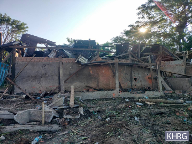
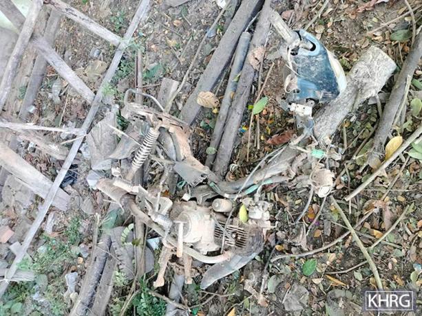
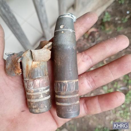
These photos were taken in January 2025 on a villager’s farm near Kk--- village, Day Loh village tract, Htaw Ta Htoo Township, Taw Oo District. From January 10th to 12th 2025, SAC soldiers in Infantry Battalion (IB)[17] #39’s army camp indiscriminately fired numerous rounds of mortar and conducted a drone attack in Day Loh village tract. Two of the bombs from the drone landed and exploded on a villager’s house near Kk--- village. The house is owned by a villager named Saw C--- and is located on his farm near the village. When the SAC conducted the drone attack, Saw C--- (82 years old) and his son, D--- (42 years old), were staying in the house and got injured. Saw C--- sustained injuries to his right hand, chest, and eyebrow bone. D--- sustained injuries to his forehead, chin, legs, and hands. Many household materials in the house were also damaged. Saw C--- was sent to Toungoo Hospital (administered by the SAC) in Toungoo Town, Daw Hpah Hkoh Township, Taw Oo District, by family members to get treatment, and D--- received medical treatment at home and recovered. Saw C--- was discharged from the hospital in February 2025 as he recovered from his injuries. His family had to pay the medical costs for the treatment. The photo on the left shows Saw C---’s house destroyed by the bomb explosion. The photo on the right shows a piece of the bomb that landed and exploded on Saw C---’s house.[18] [Photos: KHRG]
Photo Set: Burma Army air strikes resulting in casualties, destruction, displacement, and contamination in 2025
Since 2021, the Burma military regime[1] has increasingly used air strikes in Southeast Burma, resulting in widespread civilian deaths and injuries, destruction, and displacement. Based on KHRG documentation, in 2025, the Burma Army used different types of weapons, including machine guns, mortars, and various bombs, when conducting deadly air strikes on communities in the seven districts of locally-defined Karen State[2]: Doo Tha Htoo (Thaton), Taw Oo (Toungoo), Kler Lwee Htoo (Nyaunglebin), Mergui-Tavoy, Mu Traw (Hpapun), Dooplaya, and Hpa-an districts.[3] Air attacks were conducted with or without active fighting near villages, without warning or other precautionary measures before the attack.[4] Often, air strikes followed air reconnaissance. A high number of air strikes impacted community buildings, such as schools, monastery compounds, and churches, which are often clearly identifiable from the air, as well as villagers’ homes, farms, and plantations.
This Photo Set includes 83 photos (selected from a total of 3,662 photographs received in 2025), providing evidence of impacts faced by local villagers in the aftermath of Burma Army air strikes in Southeast Burma. 74 of the included photographs were taken by local community members trained by KHRG to monitor human rights conditions in their areas, and nine were taken by local villagers and authorities. The photos show casualties, destruction, displacement, and the different types of weapons used by the Burma Army during air attacks. The names of the victims, their photos, and the exact locations are censored for security and sensitivity reasons.
Further background reading on the situation of air strikes in Southeast Burma/Myanmar can be found in the following KHRG reports:
 ,
, 
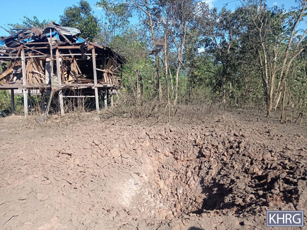
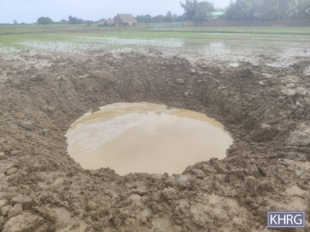
These photos were taken in March 2025 on a rubber plantation near Ll--- village, P’Saw Loh village tract, Daw Hpah Hkoh Township, Taw Oo District. On March 13th 2025, an SAC aircraft dropped two bombs on rubber plantations owned by local villagers. One bomb exploded, while the other one did not. The left photo shows a large hole in the rubber plantation where the unexploded bomb landed. The right photo shows rubber trees that were damaged by the explosion of the second bomb. Local villagers believe that these two bombs were 500-pound bombs. According to local villagers who saw the incident sites, nobody would have been safe, whether they had stayed in their houses or hidden in bunkers, if these bombs had been dropped and exploded in a village. Local villagers were very afraid.[19] [Photos: KHRG]
Photo Set: Burma Army air strikes resulting in casualties, destruction, displacement, and contamination in 2025
Since 2021, the Burma military regime[1] has increasingly used air strikes in Southeast Burma, resulting in widespread civilian deaths and injuries, destruction, and displacement. Based on KHRG documentation, in 2025, the Burma Army used different types of weapons, including machine guns, mortars, and various bombs, when conducting deadly air strikes on communities in the seven districts of locally-defined Karen State[2]: Doo Tha Htoo (Thaton), Taw Oo (Toungoo), Kler Lwee Htoo (Nyaunglebin), Mergui-Tavoy, Mu Traw (Hpapun), Dooplaya, and Hpa-an districts.[3] Air attacks were conducted with or without active fighting near villages, without warning or other precautionary measures before the attack.[4] Often, air strikes followed air reconnaissance. A high number of air strikes impacted community buildings, such as schools, monastery compounds, and churches, which are often clearly identifiable from the air, as well as villagers’ homes, farms, and plantations.
This Photo Set includes 83 photos (selected from a total of 3,662 photographs received in 2025), providing evidence of impacts faced by local villagers in the aftermath of Burma Army air strikes in Southeast Burma. 74 of the included photographs were taken by local community members trained by KHRG to monitor human rights conditions in their areas, and nine were taken by local villagers and authorities. The photos show casualties, destruction, displacement, and the different types of weapons used by the Burma Army during air attacks. The names of the victims, their photos, and the exact locations are censored for security and sensitivity reasons.
Further background reading on the situation of air strikes in Southeast Burma/Myanmar can be found in the following KHRG reports:
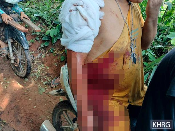
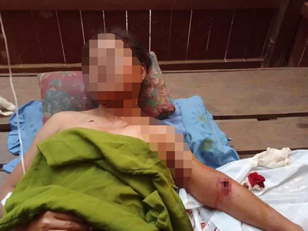
This photo was taken in May 2025 in K’lay Wah Mu Htaw village tract, Daw Hpah Hkoh Township, Taw Oo District. On May 18th 2025, around 11:30 am, an SAC fighter jet dropped two 500-pound bombs in the compound of Mm--- high school in K’lay Wah Mu Htaw village tract. The school is administered by the KECD. Only one bomb exploded. Saw E---, the school principal of Mm--- high school, was hit by a piece of the bombshell on his shoulder. Two villagers’ houses, some trees, and a toilet were also damaged. There were about 20 people, including students, local healthcare workers, and teachers in the school compound when the incident happened, who immediately ran to a stream to find safety. The injured principal sought medical treatment on the same day. The attack left all the students afraid and worried. The photo shows Saw E--- being transported to a nearby clinic by local villagers on a motorbike on May 18th 2025 after he was injured by the SAC air strike.[20] [Photo: KHRG]
Photo Set: Burma Army air strikes resulting in casualties, destruction, displacement, and contamination in 2025
Since 2021, the Burma military regime[1] has increasingly used air strikes in Southeast Burma, resulting in widespread civilian deaths and injuries, destruction, and displacement. Based on KHRG documentation, in 2025, the Burma Army used different types of weapons, including machine guns, mortars, and various bombs, when conducting deadly air strikes on communities in the seven districts of locally-defined Karen State[2]: Doo Tha Htoo (Thaton), Taw Oo (Toungoo), Kler Lwee Htoo (Nyaunglebin), Mergui-Tavoy, Mu Traw (Hpapun), Dooplaya, and Hpa-an districts.[3] Air attacks were conducted with or without active fighting near villages, without warning or other precautionary measures before the attack.[4] Often, air strikes followed air reconnaissance. A high number of air strikes impacted community buildings, such as schools, monastery compounds, and churches, which are often clearly identifiable from the air, as well as villagers’ homes, farms, and plantations.
This Photo Set includes 83 photos (selected from a total of 3,662 photographs received in 2025), providing evidence of impacts faced by local villagers in the aftermath of Burma Army air strikes in Southeast Burma. 74 of the included photographs were taken by local community members trained by KHRG to monitor human rights conditions in their areas, and nine were taken by local villagers and authorities. The photos show casualties, destruction, displacement, and the different types of weapons used by the Burma Army during air attacks. The names of the victims, their photos, and the exact locations are censored for security and sensitivity reasons.
Further background reading on the situation of air strikes in Southeast Burma/Myanmar can be found in the following KHRG reports:
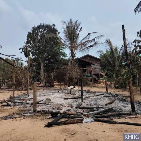
This photo was taken in January 2025 in Nn--- village, Kheh Der village tract, Ler Doh Township, Kler Lwee Htoo District. On January 1st 2025, at 9:30 pm, an SAC fighter jet dropped a 500-pound bomb in Nn--- village, damaging a villager’s house. Villagers fled to a forest after the incident. The photo shows the place where the bomb dropped and the destroyed house. Before this incident, on December 31st 2024, combined forces of the Karen National Defense Organisation (KNDO)[21] and Karen National Liberation Army (KNLA)[22] had attacked the SAC’s Hkoh Thay Kyoh army camp in Ler Doh Township. [Photo: KHRG]
Photo Set: Burma Army air strikes resulting in casualties, destruction, displacement, and contamination in 2025
Since 2021, the Burma military regime[1] has increasingly used air strikes in Southeast Burma, resulting in widespread civilian deaths and injuries, destruction, and displacement. Based on KHRG documentation, in 2025, the Burma Army used different types of weapons, including machine guns, mortars, and various bombs, when conducting deadly air strikes on communities in the seven districts of locally-defined Karen State[2]: Doo Tha Htoo (Thaton), Taw Oo (Toungoo), Kler Lwee Htoo (Nyaunglebin), Mergui-Tavoy, Mu Traw (Hpapun), Dooplaya, and Hpa-an districts.[3] Air attacks were conducted with or without active fighting near villages, without warning or other precautionary measures before the attack.[4] Often, air strikes followed air reconnaissance. A high number of air strikes impacted community buildings, such as schools, monastery compounds, and churches, which are often clearly identifiable from the air, as well as villagers’ homes, farms, and plantations.
This Photo Set includes 83 photos (selected from a total of 3,662 photographs received in 2025), providing evidence of impacts faced by local villagers in the aftermath of Burma Army air strikes in Southeast Burma. 74 of the included photographs were taken by local community members trained by KHRG to monitor human rights conditions in their areas, and nine were taken by local villagers and authorities. The photos show casualties, destruction, displacement, and the different types of weapons used by the Burma Army during air attacks. The names of the victims, their photos, and the exact locations are censored for security and sensitivity reasons.
Further background reading on the situation of air strikes in Southeast Burma/Myanmar can be found in the following KHRG reports:

KHRG received this photo on January 29th 2025, from a local leader. On January 21st 2025, SAC Light Infantry Battalion (LIB)[23] #20, based in Yay Kyi Khayung village, Inn Wine village tract, Hsaw Htee Township, Kler Lwee Htoo District conducted a drone strike onto Oo--- village and Pp--- village in Pyin Yay village tract, Hsaw Htee Township. One of the bombs from the drone was dropped in a monastery in Pp--- village. As a result, a monk was killed, and another monk was injured on his left thigh. Another bomb from the drone was dropped in front of a villager’s house in Oo--- village, owned by Ko[24] F---. Ko F--- was injured on his arms by the bomb’s shrapnel. According to local villagers, People’s Defence Force (PDF)[25] soldiers sometimes travelled through the two villages, so the villagers believe that is why the SAC targeted and attacked these two villages. The photo shows the monk, injured by the SAC drone attack. [Photo: Local leader]
Photo Set: Burma Army air strikes resulting in casualties, destruction, displacement, and contamination in 2025
Since 2021, the Burma military regime[1] has increasingly used air strikes in Southeast Burma, resulting in widespread civilian deaths and injuries, destruction, and displacement. Based on KHRG documentation, in 2025, the Burma Army used different types of weapons, including machine guns, mortars, and various bombs, when conducting deadly air strikes on communities in the seven districts of locally-defined Karen State[2]: Doo Tha Htoo (Thaton), Taw Oo (Toungoo), Kler Lwee Htoo (Nyaunglebin), Mergui-Tavoy, Mu Traw (Hpapun), Dooplaya, and Hpa-an districts.[3] Air attacks were conducted with or without active fighting near villages, without warning or other precautionary measures before the attack.[4] Often, air strikes followed air reconnaissance. A high number of air strikes impacted community buildings, such as schools, monastery compounds, and churches, which are often clearly identifiable from the air, as well as villagers’ homes, farms, and plantations.
This Photo Set includes 83 photos (selected from a total of 3,662 photographs received in 2025), providing evidence of impacts faced by local villagers in the aftermath of Burma Army air strikes in Southeast Burma. 74 of the included photographs were taken by local community members trained by KHRG to monitor human rights conditions in their areas, and nine were taken by local villagers and authorities. The photos show casualties, destruction, displacement, and the different types of weapons used by the Burma Army during air attacks. The names of the victims, their photos, and the exact locations are censored for security and sensitivity reasons.
Further background reading on the situation of air strikes in Southeast Burma/Myanmar can be found in the following KHRG reports:
 ,
, 
KHRG received these photos on January 29th 2025, from a local authority. On January 27th 2025, an SAC fighter jet dropped bombs in Qq--- village, Nyaung Pin Gyi village tract, Hsaw Htee Township, Kler Lwee Htoo District. The bombs landed and exploded in Rr--- monastery in Qq--- village. The next day, on January 28th 2025, an SAC aircraft dropped two 500-pound bombs in Qq--- village, with one of the bombs striking Rr--- monastery again. The other bomb landed on the house of a villager names U[26] G---. As a result of the two air strikes, the monastery was completely destroyed, including its roof, walls, floor, and Buddha statue. In addition, five villagers’ houses were damaged. After the incident, many local villagers fled to Pyin Yay village tract and Thet Kel Koh village tract, Hsaw Htee Township. Some villagers fled to a town nearby. Before the SAC conducted the air strike, PDF soldiers attacked SAC LIB #20 in Nyaung Pin Gyi village tract, which resulted in SAC soldiers’ casualties. The photos show Rr--- monastery in Qq--- village, destroyed by the SAC air strikes. [Photos: Local authority]
Photo Set: Burma Army air strikes resulting in casualties, destruction, displacement, and contamination in 2025
Since 2021, the Burma military regime[1] has increasingly used air strikes in Southeast Burma, resulting in widespread civilian deaths and injuries, destruction, and displacement. Based on KHRG documentation, in 2025, the Burma Army used different types of weapons, including machine guns, mortars, and various bombs, when conducting deadly air strikes on communities in the seven districts of locally-defined Karen State[2]: Doo Tha Htoo (Thaton), Taw Oo (Toungoo), Kler Lwee Htoo (Nyaunglebin), Mergui-Tavoy, Mu Traw (Hpapun), Dooplaya, and Hpa-an districts.[3] Air attacks were conducted with or without active fighting near villages, without warning or other precautionary measures before the attack.[4] Often, air strikes followed air reconnaissance. A high number of air strikes impacted community buildings, such as schools, monastery compounds, and churches, which are often clearly identifiable from the air, as well as villagers’ homes, farms, and plantations.
This Photo Set includes 83 photos (selected from a total of 3,662 photographs received in 2025), providing evidence of impacts faced by local villagers in the aftermath of Burma Army air strikes in Southeast Burma. 74 of the included photographs were taken by local community members trained by KHRG to monitor human rights conditions in their areas, and nine were taken by local villagers and authorities. The photos show casualties, destruction, displacement, and the different types of weapons used by the Burma Army during air attacks. The names of the victims, their photos, and the exact locations are censored for security and sensitivity reasons.
Further background reading on the situation of air strikes in Southeast Burma/Myanmar can be found in the following KHRG reports:
 ,
, 
These photos were taken in February 2025 in Ss--- village, Kway Kon village tract, Hsaw Htee Township, Kler Lwee Htoo District. On January 31st 2025, SAC IB #264, based in Pein Z’Loik Town, Kler Lwee Htoo District conducted a drone attack on Ss--- village, damaging an electricity generator and a house owned by Saw G---, and destroying another house owned by U H---. Before the incident, PDF soldiers patrolled the village and set up a checkpoint at its entrance. The photos show U H---’s house, destroyed by the SAC drone strike. [Photos: KHRG]
Photo Set: Burma Army air strikes resulting in casualties, destruction, displacement, and contamination in 2025
Since 2021, the Burma military regime[1] has increasingly used air strikes in Southeast Burma, resulting in widespread civilian deaths and injuries, destruction, and displacement. Based on KHRG documentation, in 2025, the Burma Army used different types of weapons, including machine guns, mortars, and various bombs, when conducting deadly air strikes on communities in the seven districts of locally-defined Karen State[2]: Doo Tha Htoo (Thaton), Taw Oo (Toungoo), Kler Lwee Htoo (Nyaunglebin), Mergui-Tavoy, Mu Traw (Hpapun), Dooplaya, and Hpa-an districts.[3] Air attacks were conducted with or without active fighting near villages, without warning or other precautionary measures before the attack.[4] Often, air strikes followed air reconnaissance. A high number of air strikes impacted community buildings, such as schools, monastery compounds, and churches, which are often clearly identifiable from the air, as well as villagers’ homes, farms, and plantations.
This Photo Set includes 83 photos (selected from a total of 3,662 photographs received in 2025), providing evidence of impacts faced by local villagers in the aftermath of Burma Army air strikes in Southeast Burma. 74 of the included photographs were taken by local community members trained by KHRG to monitor human rights conditions in their areas, and nine were taken by local villagers and authorities. The photos show casualties, destruction, displacement, and the different types of weapons used by the Burma Army during air attacks. The names of the victims, their photos, and the exact locations are censored for security and sensitivity reasons.
Further background reading on the situation of air strikes in Southeast Burma/Myanmar can be found in the following KHRG reports:
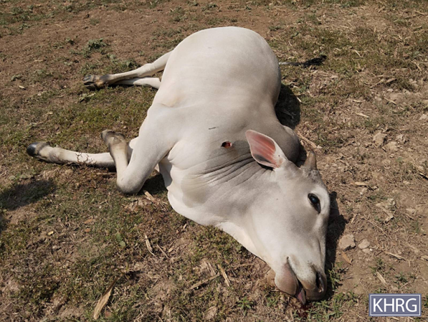
This photo was taken in February 2025 in Ss--- village, Kway Kon village tract, Hsaw Htee Township, Kler Lwee Htoo District. On February 19th, 2025, at 12:37 pm, an SAC fighter jet carried out an air strike in Ss--- village, injuring an 18-year-old villager named Naw[27] I---. She sustained an injury to her left leg. In addition, the air strike destroyed two houses, killed two cows, and injured three cows owned by local villagers. The photo shows a cow, killed by the SAC air strike. [Photo: KHRG]
Photo Set: Burma Army air strikes resulting in casualties, destruction, displacement, and contamination in 2025
Since 2021, the Burma military regime[1] has increasingly used air strikes in Southeast Burma, resulting in widespread civilian deaths and injuries, destruction, and displacement. Based on KHRG documentation, in 2025, the Burma Army used different types of weapons, including machine guns, mortars, and various bombs, when conducting deadly air strikes on communities in the seven districts of locally-defined Karen State[2]: Doo Tha Htoo (Thaton), Taw Oo (Toungoo), Kler Lwee Htoo (Nyaunglebin), Mergui-Tavoy, Mu Traw (Hpapun), Dooplaya, and Hpa-an districts.[3] Air attacks were conducted with or without active fighting near villages, without warning or other precautionary measures before the attack.[4] Often, air strikes followed air reconnaissance. A high number of air strikes impacted community buildings, such as schools, monastery compounds, and churches, which are often clearly identifiable from the air, as well as villagers’ homes, farms, and plantations.
This Photo Set includes 83 photos (selected from a total of 3,662 photographs received in 2025), providing evidence of impacts faced by local villagers in the aftermath of Burma Army air strikes in Southeast Burma. 74 of the included photographs were taken by local community members trained by KHRG to monitor human rights conditions in their areas, and nine were taken by local villagers and authorities. The photos show casualties, destruction, displacement, and the different types of weapons used by the Burma Army during air attacks. The names of the victims, their photos, and the exact locations are censored for security and sensitivity reasons.
Further background reading on the situation of air strikes in Southeast Burma/Myanmar can be found in the following KHRG reports:
This photo was taken in March 2025 in Tt--- place near Uu--- village, Kheh Der village tract, Ler Doh Township, Kler Lwee Htoo District. On March 25th 2025, an SAC fighter jet dropped what villagers believed to be an incendiary bomb onto Tt--- place. As a result, a shop and a house, owned by a villager named Saw J---, were burned to the ground. Saw J--- said that the value of his shop was about 40,000,000 Kyat (19,000 USD[28]). No villagers were injured. Before the incident, on March 24th 2025, an SAC drone flew over Tt--- place to conduct reconnaissance. The photo shows villagers trying to stop the fire of the burning shop. [Photo: KHRG]
Photo Set: Burma Army air strikes resulting in casualties, destruction, displacement, and contamination in 2025
Since 2021, the Burma military regime[1] has increasingly used air strikes in Southeast Burma, resulting in widespread civilian deaths and injuries, destruction, and displacement. Based on KHRG documentation, in 2025, the Burma Army used different types of weapons, including machine guns, mortars, and various bombs, when conducting deadly air strikes on communities in the seven districts of locally-defined Karen State[2]: Doo Tha Htoo (Thaton), Taw Oo (Toungoo), Kler Lwee Htoo (Nyaunglebin), Mergui-Tavoy, Mu Traw (Hpapun), Dooplaya, and Hpa-an districts.[3] Air attacks were conducted with or without active fighting near villages, without warning or other precautionary measures before the attack.[4] Often, air strikes followed air reconnaissance. A high number of air strikes impacted community buildings, such as schools, monastery compounds, and churches, which are often clearly identifiable from the air, as well as villagers’ homes, farms, and plantations.
This Photo Set includes 83 photos (selected from a total of 3,662 photographs received in 2025), providing evidence of impacts faced by local villagers in the aftermath of Burma Army air strikes in Southeast Burma. 74 of the included photographs were taken by local community members trained by KHRG to monitor human rights conditions in their areas, and nine were taken by local villagers and authorities. The photos show casualties, destruction, displacement, and the different types of weapons used by the Burma Army during air attacks. The names of the victims, their photos, and the exact locations are censored for security and sensitivity reasons.
Further background reading on the situation of air strikes in Southeast Burma/Myanmar can be found in the following KHRG reports:
 ,
, 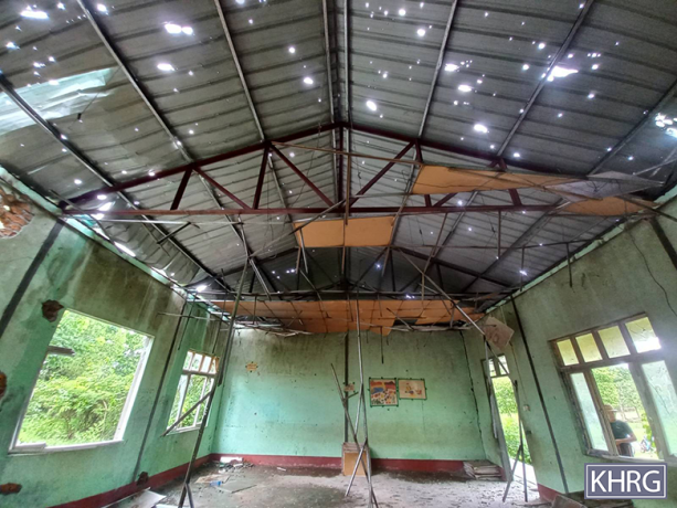
These photos were taken in May 2025, in Vv--- village, Pyin Yay village tract, Hsaw Htee Township, Kler Lwee Htoo District. On May 11th 2025, at 7:20 am, an SAC fighter jet flew over Vv--- village three times to conduct air reconnaissance. Villagers believe that the aircraft came from Toungoo Town in Taw Oo District. The third time it flew over, it dropped a 500-pound bomb, which landed and exploded behind Vv--- high school, inside the school’s compound, damaging it. The high school is administered by the KECD. The bomb’s shrapnel went through the window of the house of Ko K---, a 39-year-old villager who lived near the school’s compound, and hit him on his waist and the back of his shoulders, causing minor injuries. The house was also slightly damaged. The photo on the left shows the school’s walls and windows damaged.[29] The photo on the right shows the high school’s roof, full of holes, and the ceiling collapsing as a result of the air strike. [Photos: KHRG]
Photo Set: Burma Army air strikes resulting in casualties, destruction, displacement, and contamination in 2025
Since 2021, the Burma military regime[1] has increasingly used air strikes in Southeast Burma, resulting in widespread civilian deaths and injuries, destruction, and displacement. Based on KHRG documentation, in 2025, the Burma Army used different types of weapons, including machine guns, mortars, and various bombs, when conducting deadly air strikes on communities in the seven districts of locally-defined Karen State[2]: Doo Tha Htoo (Thaton), Taw Oo (Toungoo), Kler Lwee Htoo (Nyaunglebin), Mergui-Tavoy, Mu Traw (Hpapun), Dooplaya, and Hpa-an districts.[3] Air attacks were conducted with or without active fighting near villages, without warning or other precautionary measures before the attack.[4] Often, air strikes followed air reconnaissance. A high number of air strikes impacted community buildings, such as schools, monastery compounds, and churches, which are often clearly identifiable from the air, as well as villagers’ homes, farms, and plantations.
This Photo Set includes 83 photos (selected from a total of 3,662 photographs received in 2025), providing evidence of impacts faced by local villagers in the aftermath of Burma Army air strikes in Southeast Burma. 74 of the included photographs were taken by local community members trained by KHRG to monitor human rights conditions in their areas, and nine were taken by local villagers and authorities. The photos show casualties, destruction, displacement, and the different types of weapons used by the Burma Army during air attacks. The names of the victims, their photos, and the exact locations are censored for security and sensitivity reasons.
Further background reading on the situation of air strikes in Southeast Burma/Myanmar can be found in the following KHRG reports:
This photo was taken in June 2025 in a field near Ww--- village, Hay Tha Weh village tract, Ler Doh Township, Kler Lwee Htoo District. On June 28th 2025, at around 2 pm, an SAC fighter jet dropped two 500-pound bombs in Ww--- village area. The two bombs landed in a rice field, exploding and causing damage to the field. The rice field is about 40 cubits (18 metres)[30] away from the villagers’ houses. In addition, two villagers (Saw L--- and Naw M---) were injured. Eight villagers’ houses were damaged. The two injured villagers were sent to Xx--- hospital in Ler Doh Township, administered by the KDHW. The photo shows the rice field, damaged by the SAC air strike on June 28th 2025. [Photo: KHRG]
Photo Set: Burma Army air strikes resulting in casualties, destruction, displacement, and contamination in 2025
Since 2021, the Burma military regime[1] has increasingly used air strikes in Southeast Burma, resulting in widespread civilian deaths and injuries, destruction, and displacement. Based on KHRG documentation, in 2025, the Burma Army used different types of weapons, including machine guns, mortars, and various bombs, when conducting deadly air strikes on communities in the seven districts of locally-defined Karen State[2]: Doo Tha Htoo (Thaton), Taw Oo (Toungoo), Kler Lwee Htoo (Nyaunglebin), Mergui-Tavoy, Mu Traw (Hpapun), Dooplaya, and Hpa-an districts.[3] Air attacks were conducted with or without active fighting near villages, without warning or other precautionary measures before the attack.[4] Often, air strikes followed air reconnaissance. A high number of air strikes impacted community buildings, such as schools, monastery compounds, and churches, which are often clearly identifiable from the air, as well as villagers’ homes, farms, and plantations.
This Photo Set includes 83 photos (selected from a total of 3,662 photographs received in 2025), providing evidence of impacts faced by local villagers in the aftermath of Burma Army air strikes in Southeast Burma. 74 of the included photographs were taken by local community members trained by KHRG to monitor human rights conditions in their areas, and nine were taken by local villagers and authorities. The photos show casualties, destruction, displacement, and the different types of weapons used by the Burma Army during air attacks. The names of the victims, their photos, and the exact locations are censored for security and sensitivity reasons.
Further background reading on the situation of air strikes in Southeast Burma/Myanmar can be found in the following KHRG reports:
This photo was taken in July 2025 in a clinic in Ler Doh Township, Kler Lwee Htoo District. On July 5th 2025, at around 5:50 pm, the Burma Army carried out drone strikes and dropped two bombs on Yy--- village, Taw Kyaung Pauk village tract, Ler Doh Township. The first bomb landed in the school compound. As a result, four villagers were killed on the spot, and four others, including two children and a pregnant woman, were severely injured. All were displaced villagers from Wah Pin Su village tract, Moo Township, Kler Lwee Htoo District. One injured child died on the way to the hospital, and another child died upon arrival. Only two out of the four injured villagers survived. A school building was also destroyed in the attack. The second bomb landed in another area but failed to detonate. The village school and a school nearby were closed down due to security concerns after the incident. The photo shows one of the injured villagers receiving medical treatment in a KDHW-run clinic. [Photo: KHRG]
Photo Set: Burma Army air strikes resulting in casualties, destruction, displacement, and contamination in 2025
Since 2021, the Burma military regime[1] has increasingly used air strikes in Southeast Burma, resulting in widespread civilian deaths and injuries, destruction, and displacement. Based on KHRG documentation, in 2025, the Burma Army used different types of weapons, including machine guns, mortars, and various bombs, when conducting deadly air strikes on communities in the seven districts of locally-defined Karen State[2]: Doo Tha Htoo (Thaton), Taw Oo (Toungoo), Kler Lwee Htoo (Nyaunglebin), Mergui-Tavoy, Mu Traw (Hpapun), Dooplaya, and Hpa-an districts.[3] Air attacks were conducted with or without active fighting near villages, without warning or other precautionary measures before the attack.[4] Often, air strikes followed air reconnaissance. A high number of air strikes impacted community buildings, such as schools, monastery compounds, and churches, which are often clearly identifiable from the air, as well as villagers’ homes, farms, and plantations.
This Photo Set includes 83 photos (selected from a total of 3,662 photographs received in 2025), providing evidence of impacts faced by local villagers in the aftermath of Burma Army air strikes in Southeast Burma. 74 of the included photographs were taken by local community members trained by KHRG to monitor human rights conditions in their areas, and nine were taken by local villagers and authorities. The photos show casualties, destruction, displacement, and the different types of weapons used by the Burma Army during air attacks. The names of the victims, their photos, and the exact locations are censored for security and sensitivity reasons.
Further background reading on the situation of air strikes in Southeast Burma/Myanmar can be found in the following KHRG reports:
 ,
, 
These photos were taken in December 2025 in Zz--- village, Inn Dine Kone village tract, Ler Doh Township, Kler Lwee Htoo District. On December 10th 2025, at around 8 pm, a Burma Army fighter jet dropped a 500-pound bomb on Zz--- village. As a result of the bomb’s explosion, a 46-year-old villager was killed. Additionally, five villagers’ houses were damaged, and a motorbike was destroyed. Five cows were killed, and one was injured, all owned by a local villager. The photo on the left shows one of the villagers’ houses, damaged by the Burma Army’s air strike. The photo on the right shows a motorbike, destroyed by the air strike. [Photos: KHRG]
Photo Set: Burma Army air strikes resulting in casualties, destruction, displacement, and contamination in 2025
Since 2021, the Burma military regime[1] has increasingly used air strikes in Southeast Burma, resulting in widespread civilian deaths and injuries, destruction, and displacement. Based on KHRG documentation, in 2025, the Burma Army used different types of weapons, including machine guns, mortars, and various bombs, when conducting deadly air strikes on communities in the seven districts of locally-defined Karen State[2]: Doo Tha Htoo (Thaton), Taw Oo (Toungoo), Kler Lwee Htoo (Nyaunglebin), Mergui-Tavoy, Mu Traw (Hpapun), Dooplaya, and Hpa-an districts.[3] Air attacks were conducted with or without active fighting near villages, without warning or other precautionary measures before the attack.[4] Often, air strikes followed air reconnaissance. A high number of air strikes impacted community buildings, such as schools, monastery compounds, and churches, which are often clearly identifiable from the air, as well as villagers’ homes, farms, and plantations.
This Photo Set includes 83 photos (selected from a total of 3,662 photographs received in 2025), providing evidence of impacts faced by local villagers in the aftermath of Burma Army air strikes in Southeast Burma. 74 of the included photographs were taken by local community members trained by KHRG to monitor human rights conditions in their areas, and nine were taken by local villagers and authorities. The photos show casualties, destruction, displacement, and the different types of weapons used by the Burma Army during air attacks. The names of the victims, their photos, and the exact locations are censored for security and sensitivity reasons.
Further background reading on the situation of air strikes in Southeast Burma/Myanmar can be found in the following KHRG reports:
 ,
, 
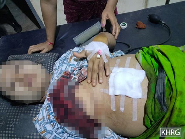
KHRG received these photos from a local authority on January 8th 2025. On January 7th 2025, at around 11:30 am, an SAC fighter jet from Myeik Town, Mergui-Tavoy District, carried out an air strike on Ab------ village in Paw Hkoh area, K’Ser Doh Township, Mergui-Tavoy District. The air strike happened after the Karen New Year’s[31] ceremony took place in the area on December 30th 2024. The fighter jet dropped three bombs and strafed the village. As a result, two villagers, Saw N--- (aged 34) and Naw O--- (aged 33), were seriously injured. Saw N--- sustained injuries to his legs, hands, and chest. Naw O--- sustained injuries to her legs, hands, and other parts of the body. After the incident, they were both sent to a KDHW-administered clinic in Ac--- village, Paw Hkoh area. The photos show the two villagers receiving medical treatment in the clinic. As they were seriously injured, they were later transferred to a hospital in Ad--- Town, in Thailand’s Kanchanaburi province. The air strike also damaged a motorbike, two villagers’ houses, and multiple plantations, and killed livestock. Villagers reported that it was the first time an air strike had happened in the area. Villagers were worried and had major security concerns regarding further attacks in the area. [Photo: Local authority]
Photo Set: Burma Army air strikes resulting in casualties, destruction, displacement, and contamination in 2025
Since 2021, the Burma military regime[1] has increasingly used air strikes in Southeast Burma, resulting in widespread civilian deaths and injuries, destruction, and displacement. Based on KHRG documentation, in 2025, the Burma Army used different types of weapons, including machine guns, mortars, and various bombs, when conducting deadly air strikes on communities in the seven districts of locally-defined Karen State[2]: Doo Tha Htoo (Thaton), Taw Oo (Toungoo), Kler Lwee Htoo (Nyaunglebin), Mergui-Tavoy, Mu Traw (Hpapun), Dooplaya, and Hpa-an districts.[3] Air attacks were conducted with or without active fighting near villages, without warning or other precautionary measures before the attack.[4] Often, air strikes followed air reconnaissance. A high number of air strikes impacted community buildings, such as schools, monastery compounds, and churches, which are often clearly identifiable from the air, as well as villagers’ homes, farms, and plantations.
This Photo Set includes 83 photos (selected from a total of 3,662 photographs received in 2025), providing evidence of impacts faced by local villagers in the aftermath of Burma Army air strikes in Southeast Burma. 74 of the included photographs were taken by local community members trained by KHRG to monitor human rights conditions in their areas, and nine were taken by local villagers and authorities. The photos show casualties, destruction, displacement, and the different types of weapons used by the Burma Army during air attacks. The names of the victims, their photos, and the exact locations are censored for security and sensitivity reasons.
Further background reading on the situation of air strikes in Southeast Burma/Myanmar can be found in the following KHRG reports:
 ,
, 
These photos were taken in July 2025 in Ah--- village, Maw Doh village tract, T’Naw T’Ree Township, Mergui-Tavoy District. On July 10th 2025, a Burma Army fighter jet dropped bombs onto Ah--- village. Fighting did not happen in the village on the day of the air strike. This is the first time that the Burma Army conducted an air strike on the village. As a result of the air strike, two villagers’ houses, betel nut trees, and a well were damaged. The photo on the left shows one of the villagers’ damaged houses, while the photo on the right shows pieces of the bombs that landed in Ah--- village. Children were studying in the village school when the air strike happened. After the incident, the school was forced to close. [Photos: KHRG]
Photo Set: Burma Army air strikes resulting in casualties, destruction, displacement, and contamination in 2025
Since 2021, the Burma military regime[1] has increasingly used air strikes in Southeast Burma, resulting in widespread civilian deaths and injuries, destruction, and displacement. Based on KHRG documentation, in 2025, the Burma Army used different types of weapons, including machine guns, mortars, and various bombs, when conducting deadly air strikes on communities in the seven districts of locally-defined Karen State[2]: Doo Tha Htoo (Thaton), Taw Oo (Toungoo), Kler Lwee Htoo (Nyaunglebin), Mergui-Tavoy, Mu Traw (Hpapun), Dooplaya, and Hpa-an districts.[3] Air attacks were conducted with or without active fighting near villages, without warning or other precautionary measures before the attack.[4] Often, air strikes followed air reconnaissance. A high number of air strikes impacted community buildings, such as schools, monastery compounds, and churches, which are often clearly identifiable from the air, as well as villagers’ homes, farms, and plantations.
This Photo Set includes 83 photos (selected from a total of 3,662 photographs received in 2025), providing evidence of impacts faced by local villagers in the aftermath of Burma Army air strikes in Southeast Burma. 74 of the included photographs were taken by local community members trained by KHRG to monitor human rights conditions in their areas, and nine were taken by local villagers and authorities. The photos show casualties, destruction, displacement, and the different types of weapons used by the Burma Army during air attacks. The names of the victims, their photos, and the exact locations are censored for security and sensitivity reasons.
Further background reading on the situation of air strikes in Southeast Burma/Myanmar can be found in the following KHRG reports:
 ,
, 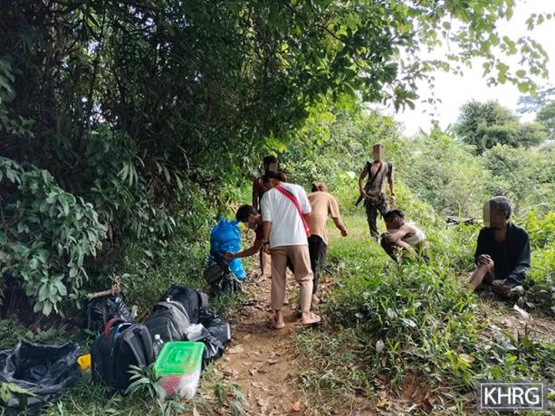
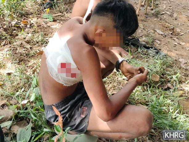
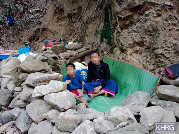
These photos were taken in July 2025, in Ae--- place, Lay Nya Hta Hkaw area, Ler K’Saw Township, Mergui-Tavoy District. On July 16th 2025, at 1:45 pm, a Burma Army aircraft dropped bombs on Ae--- place. As a result, four villagers, including two children, were injured, and a villager’s house was burned. After the incident, some villagers in Ae--- place fled to a forest. PDF medics and KDHW staff provided medical treatment to the injured villagers. Villagers were afraid due to the Burma Army air strike. Following the incident, schools from Af--- and Ag--- villages in Lay Nya Hta Hkaw area were forced to close. The photo on the left shows one of the injured villagers receiving medical treatment in the forest to which they fled. The photo on the right shows where villagers fled in the forest. [Photos: KHRG]
Photo Set: Burma Army air strikes resulting in casualties, destruction, displacement, and contamination in 2025
Since 2021, the Burma military regime[1] has increasingly used air strikes in Southeast Burma, resulting in widespread civilian deaths and injuries, destruction, and displacement. Based on KHRG documentation, in 2025, the Burma Army used different types of weapons, including machine guns, mortars, and various bombs, when conducting deadly air strikes on communities in the seven districts of locally-defined Karen State[2]: Doo Tha Htoo (Thaton), Taw Oo (Toungoo), Kler Lwee Htoo (Nyaunglebin), Mergui-Tavoy, Mu Traw (Hpapun), Dooplaya, and Hpa-an districts.[3] Air attacks were conducted with or without active fighting near villages, without warning or other precautionary measures before the attack.[4] Often, air strikes followed air reconnaissance. A high number of air strikes impacted community buildings, such as schools, monastery compounds, and churches, which are often clearly identifiable from the air, as well as villagers’ homes, farms, and plantations.
This Photo Set includes 83 photos (selected from a total of 3,662 photographs received in 2025), providing evidence of impacts faced by local villagers in the aftermath of Burma Army air strikes in Southeast Burma. 74 of the included photographs were taken by local community members trained by KHRG to monitor human rights conditions in their areas, and nine were taken by local villagers and authorities. The photos show casualties, destruction, displacement, and the different types of weapons used by the Burma Army during air attacks. The names of the victims, their photos, and the exact locations are censored for security and sensitivity reasons.
Further background reading on the situation of air strikes in Southeast Burma/Myanmar can be found in the following KHRG reports:
 ,
, 
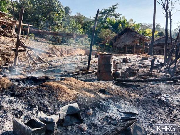
These photos were taken in August 2025 in Ai--- village, K’Ser Kler area, K’Ser Doh Township, Mergui-Tavoy District. On August 25th 2025, around 100 Burma Army soldiers from Light Infantry Battalion (LIB) #404, based in Th’Yeh Chaung Town, Mergui-Tavoy District, travelled to Aj--- village and Ai--- village, K’Ser Kler area. When they arrived at Aj--- village, they were attacked by KNLA Company #1, under Battalion #12. Some Burma Army soldiers were injured in the attack. After, Burma Army soldiers burned down 58 villagers’ houses in Aj--- village. On August 26th 2025, Burma Army soldiers patrolled to Ai--- village. When they arrived in Ai--- village, KNLA Company #1 attacked them again. Then, Burma Army soldiers burned 20 villagers’ houses in Ai--- village. Following the attack, a Burma Army aircraft conducted an air strike in Ai--- village, destroying the village monastery and damaging plantations owned by villagers. The photos show the destroyed monastery buildings. [Photos: KHRG]
Photo Set: Burma Army air strikes resulting in casualties, destruction, displacement, and contamination in 2025
Since 2021, the Burma military regime[1] has increasingly used air strikes in Southeast Burma, resulting in widespread civilian deaths and injuries, destruction, and displacement. Based on KHRG documentation, in 2025, the Burma Army used different types of weapons, including machine guns, mortars, and various bombs, when conducting deadly air strikes on communities in the seven districts of locally-defined Karen State[2]: Doo Tha Htoo (Thaton), Taw Oo (Toungoo), Kler Lwee Htoo (Nyaunglebin), Mergui-Tavoy, Mu Traw (Hpapun), Dooplaya, and Hpa-an districts.[3] Air attacks were conducted with or without active fighting near villages, without warning or other precautionary measures before the attack.[4] Often, air strikes followed air reconnaissance. A high number of air strikes impacted community buildings, such as schools, monastery compounds, and churches, which are often clearly identifiable from the air, as well as villagers’ homes, farms, and plantations.
This Photo Set includes 83 photos (selected from a total of 3,662 photographs received in 2025), providing evidence of impacts faced by local villagers in the aftermath of Burma Army air strikes in Southeast Burma. 74 of the included photographs were taken by local community members trained by KHRG to monitor human rights conditions in their areas, and nine were taken by local villagers and authorities. The photos show casualties, destruction, displacement, and the different types of weapons used by the Burma Army during air attacks. The names of the victims, their photos, and the exact locations are censored for security and sensitivity reasons.
Further background reading on the situation of air strikes in Southeast Burma/Myanmar can be found in the following KHRG reports:
 ,
,  ,
,  ,
, 
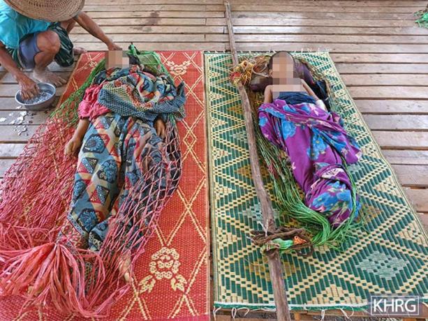
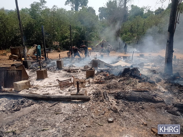
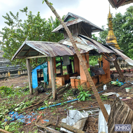
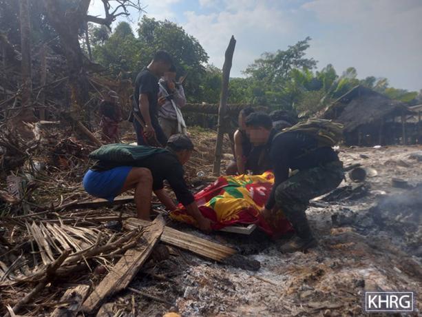
These photos were taken in January and February 2025 in Kyaw Pa village tract, Bu Tho Township, Mu Traw District. On January 28th 2025, the SAC carried out an air strike on Ak------ village, Kyaw Pa village tract. The attack caused several casualties: four villagers (including one child) were killed, while six others (including two children) were injured. Additionally, five houses were completely burned down by the air strike. Consequently, all residents of Ak--- village were forced to flee. These displaced villagers needed food, shelter, and healthcare support in their hiding locations in Bu Tho Township (as of June 2025), although they received some initial support from the Karen Women’s Organisation (KWO)[32]. On January 28th 2025, the SAC also conducted an air strike near Al--- village, Kyaw Pa village tract, destroying a monastery and several other buildings. As a result, villagers from Al--- village fled to the forest to escape further attacks. The left photo on the top row shows the remains of villagers’ houses that were burned down and destroyed by the SAC air strike conducted on January 28th 2025 in Ak--- village. The right photo on the top row shows Ak--- displaced villagers due to the SAC air strike. In the photo, they are staying at the bottom of a valley in the forest near Ak--- village. The left photo on the bottom row shows villagers trying to recover the dead bodies of villagers from a burned-down house. The right photo on the bottom row shows the monastery that was destroyed by the SAC air strike that happened on Al--- village.[33] [Photos: KHRG]
Photo Set: Burma Army air strikes resulting in casualties, destruction, displacement, and contamination in 2025
Since 2021, the Burma military regime[1] has increasingly used air strikes in Southeast Burma, resulting in widespread civilian deaths and injuries, destruction, and displacement. Based on KHRG documentation, in 2025, the Burma Army used different types of weapons, including machine guns, mortars, and various bombs, when conducting deadly air strikes on communities in the seven districts of locally-defined Karen State[2]: Doo Tha Htoo (Thaton), Taw Oo (Toungoo), Kler Lwee Htoo (Nyaunglebin), Mergui-Tavoy, Mu Traw (Hpapun), Dooplaya, and Hpa-an districts.[3] Air attacks were conducted with or without active fighting near villages, without warning or other precautionary measures before the attack.[4] Often, air strikes followed air reconnaissance. A high number of air strikes impacted community buildings, such as schools, monastery compounds, and churches, which are often clearly identifiable from the air, as well as villagers’ homes, farms, and plantations.
This Photo Set includes 83 photos (selected from a total of 3,662 photographs received in 2025), providing evidence of impacts faced by local villagers in the aftermath of Burma Army air strikes in Southeast Burma. 74 of the included photographs were taken by local community members trained by KHRG to monitor human rights conditions in their areas, and nine were taken by local villagers and authorities. The photos show casualties, destruction, displacement, and the different types of weapons used by the Burma Army during air attacks. The names of the victims, their photos, and the exact locations are censored for security and sensitivity reasons.
Further background reading on the situation of air strikes in Southeast Burma/Myanmar can be found in the following KHRG reports:
 ,
,  ,
, 
The photo was taken in January 2025, Am--- village, K’ter Tee village tract, Dwe Loh Township, Mu Traw District. In January 2025, an SAC fighter jet conducted an air strike on Am--- village while fighting was taking place between SAC soldiers and KNLA soldiers near the village. As a result, several villagers’ houses were damaged and destroyed. The photos show villagers’ houses destroyed and damaged by the SAC air strike. [Photos: KHRG]
Photo Set: Burma Army air strikes resulting in casualties, destruction, displacement, and contamination in 2025
Since 2021, the Burma military regime[1] has increasingly used air strikes in Southeast Burma, resulting in widespread civilian deaths and injuries, destruction, and displacement. Based on KHRG documentation, in 2025, the Burma Army used different types of weapons, including machine guns, mortars, and various bombs, when conducting deadly air strikes on communities in the seven districts of locally-defined Karen State[2]: Doo Tha Htoo (Thaton), Taw Oo (Toungoo), Kler Lwee Htoo (Nyaunglebin), Mergui-Tavoy, Mu Traw (Hpapun), Dooplaya, and Hpa-an districts.[3] Air attacks were conducted with or without active fighting near villages, without warning or other precautionary measures before the attack.[4] Often, air strikes followed air reconnaissance. A high number of air strikes impacted community buildings, such as schools, monastery compounds, and churches, which are often clearly identifiable from the air, as well as villagers’ homes, farms, and plantations.
This Photo Set includes 83 photos (selected from a total of 3,662 photographs received in 2025), providing evidence of impacts faced by local villagers in the aftermath of Burma Army air strikes in Southeast Burma. 74 of the included photographs were taken by local community members trained by KHRG to monitor human rights conditions in their areas, and nine were taken by local villagers and authorities. The photos show casualties, destruction, displacement, and the different types of weapons used by the Burma Army during air attacks. The names of the victims, their photos, and the exact locations are censored for security and sensitivity reasons.
Further background reading on the situation of air strikes in Southeast Burma/Myanmar can be found in the following KHRG reports:
 ,
, 
These photos were taken in March 2025 in An--- village, Ma Htaw village tract, Dwe Lo Township, Mu Traw District. On March 19th 2025, at 5 am, an SAC fighter jet dropped a 500-pound bomb on An--- village. The bomb landed and exploded in a compound of a nursery school in the village, damaging the school buildings (administered by the KECD) and several villagers’ houses nearby. The photos show the destruction of the school buildings in An--- village. [Photos: KHRG]
Photo Set: Burma Army air strikes resulting in casualties, destruction, displacement, and contamination in 2025
Since 2021, the Burma military regime[1] has increasingly used air strikes in Southeast Burma, resulting in widespread civilian deaths and injuries, destruction, and displacement. Based on KHRG documentation, in 2025, the Burma Army used different types of weapons, including machine guns, mortars, and various bombs, when conducting deadly air strikes on communities in the seven districts of locally-defined Karen State[2]: Doo Tha Htoo (Thaton), Taw Oo (Toungoo), Kler Lwee Htoo (Nyaunglebin), Mergui-Tavoy, Mu Traw (Hpapun), Dooplaya, and Hpa-an districts.[3] Air attacks were conducted with or without active fighting near villages, without warning or other precautionary measures before the attack.[4] Often, air strikes followed air reconnaissance. A high number of air strikes impacted community buildings, such as schools, monastery compounds, and churches, which are often clearly identifiable from the air, as well as villagers’ homes, farms, and plantations.
This Photo Set includes 83 photos (selected from a total of 3,662 photographs received in 2025), providing evidence of impacts faced by local villagers in the aftermath of Burma Army air strikes in Southeast Burma. 74 of the included photographs were taken by local community members trained by KHRG to monitor human rights conditions in their areas, and nine were taken by local villagers and authorities. The photos show casualties, destruction, displacement, and the different types of weapons used by the Burma Army during air attacks. The names of the victims, their photos, and the exact locations are censored for security and sensitivity reasons.
Further background reading on the situation of air strikes in Southeast Burma/Myanmar can be found in the following KHRG reports:
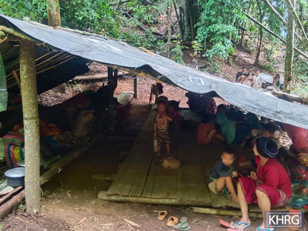 ,
, 
These photos were taken in May 2025 in a forest near Ao--- village, Ler Muh Plaw village tract, Lu Thaw Township, Mu Traw District. On April 21st 2025, the SAC conducted an air strike on Ao--- village, damaging five villagers’ houses and destroying one villager’s house. After the incident, local villagers from the village fled to a forest nearby for their safety. The photos show the displaced villagers hiding in the forest. Some of the displaced villagers faced food shortages and a lack of access to shelter, so it was very difficult for them during the displacement. [Photos: KHRG]
Photo Set: Burma Army air strikes resulting in casualties, destruction, displacement, and contamination in 2025
Since 2021, the Burma military regime[1] has increasingly used air strikes in Southeast Burma, resulting in widespread civilian deaths and injuries, destruction, and displacement. Based on KHRG documentation, in 2025, the Burma Army used different types of weapons, including machine guns, mortars, and various bombs, when conducting deadly air strikes on communities in the seven districts of locally-defined Karen State[2]: Doo Tha Htoo (Thaton), Taw Oo (Toungoo), Kler Lwee Htoo (Nyaunglebin), Mergui-Tavoy, Mu Traw (Hpapun), Dooplaya, and Hpa-an districts.[3] Air attacks were conducted with or without active fighting near villages, without warning or other precautionary measures before the attack.[4] Often, air strikes followed air reconnaissance. A high number of air strikes impacted community buildings, such as schools, monastery compounds, and churches, which are often clearly identifiable from the air, as well as villagers’ homes, farms, and plantations.
This Photo Set includes 83 photos (selected from a total of 3,662 photographs received in 2025), providing evidence of impacts faced by local villagers in the aftermath of Burma Army air strikes in Southeast Burma. 74 of the included photographs were taken by local community members trained by KHRG to monitor human rights conditions in their areas, and nine were taken by local villagers and authorities. The photos show casualties, destruction, displacement, and the different types of weapons used by the Burma Army during air attacks. The names of the victims, their photos, and the exact locations are censored for security and sensitivity reasons.
Further background reading on the situation of air strikes in Southeast Burma/Myanmar can be found in the following KHRG reports:
This photo was taken in July 2025 in a forest in Pay Kay village tract, Lu Thaw Township, Mu Traw District. On January 12th 2023, the SAC conducted an air strike in Ap--- village, Pay Kay village tract, causing damage to the village church, the village school, and several villagers’ houses. The air strike killed five villagers and injured two others. After the incident, many villagers, including children, fled from the village. The school in the village was still closed as of February 2026. The photo shows displaced children from Ap--- village studying in hidden place in the forest. [Photo: KHRG]
Photo Set: Burma Army air strikes resulting in casualties, destruction, displacement, and contamination in 2025
Since 2021, the Burma military regime[1] has increasingly used air strikes in Southeast Burma, resulting in widespread civilian deaths and injuries, destruction, and displacement. Based on KHRG documentation, in 2025, the Burma Army used different types of weapons, including machine guns, mortars, and various bombs, when conducting deadly air strikes on communities in the seven districts of locally-defined Karen State[2]: Doo Tha Htoo (Thaton), Taw Oo (Toungoo), Kler Lwee Htoo (Nyaunglebin), Mergui-Tavoy, Mu Traw (Hpapun), Dooplaya, and Hpa-an districts.[3] Air attacks were conducted with or without active fighting near villages, without warning or other precautionary measures before the attack.[4] Often, air strikes followed air reconnaissance. A high number of air strikes impacted community buildings, such as schools, monastery compounds, and churches, which are often clearly identifiable from the air, as well as villagers’ homes, farms, and plantations.
This Photo Set includes 83 photos (selected from a total of 3,662 photographs received in 2025), providing evidence of impacts faced by local villagers in the aftermath of Burma Army air strikes in Southeast Burma. 74 of the included photographs were taken by local community members trained by KHRG to monitor human rights conditions in their areas, and nine were taken by local villagers and authorities. The photos show casualties, destruction, displacement, and the different types of weapons used by the Burma Army during air attacks. The names of the victims, their photos, and the exact locations are censored for security and sensitivity reasons.
Further background reading on the situation of air strikes in Southeast Burma/Myanmar can be found in the following KHRG reports:
 ,
, 
These photos were taken in December 2025 in An--- village, Ma Htaw village tract, Dwe Lo Township, Mu Traw District. On November 29th 2025, at around 9 am, a Burma Army Y-12 aircraft dropped two bombs in An--- village. One of the bombs landed and exploded in a villager’s plantation in the village, destroying a spirit house and some trees, owned by a villager named Naw P---. The other bomb landed and exploded near a house, owned by another villager in the village, but there were no damages reported. No villager was injured or killed by the explosions, as villagers were not in their houses and plantations during the incident. The photo on the left shows the tail of the bomb that landed in Naw P---’s plantation. The photo on the right shows a spirit house destroyed by the bomb’s explosion. [Photos: KHRG]
Photo Set: Burma Army air strikes resulting in casualties, destruction, displacement, and contamination in 2025
Since 2021, the Burma military regime[1] has increasingly used air strikes in Southeast Burma, resulting in widespread civilian deaths and injuries, destruction, and displacement. Based on KHRG documentation, in 2025, the Burma Army used different types of weapons, including machine guns, mortars, and various bombs, when conducting deadly air strikes on communities in the seven districts of locally-defined Karen State[2]: Doo Tha Htoo (Thaton), Taw Oo (Toungoo), Kler Lwee Htoo (Nyaunglebin), Mergui-Tavoy, Mu Traw (Hpapun), Dooplaya, and Hpa-an districts.[3] Air attacks were conducted with or without active fighting near villages, without warning or other precautionary measures before the attack.[4] Often, air strikes followed air reconnaissance. A high number of air strikes impacted community buildings, such as schools, monastery compounds, and churches, which are often clearly identifiable from the air, as well as villagers’ homes, farms, and plantations.
This Photo Set includes 83 photos (selected from a total of 3,662 photographs received in 2025), providing evidence of impacts faced by local villagers in the aftermath of Burma Army air strikes in Southeast Burma. 74 of the included photographs were taken by local community members trained by KHRG to monitor human rights conditions in their areas, and nine were taken by local villagers and authorities. The photos show casualties, destruction, displacement, and the different types of weapons used by the Burma Army during air attacks. The names of the victims, their photos, and the exact locations are censored for security and sensitivity reasons.
Further background reading on the situation of air strikes in Southeast Burma/Myanmar can be found in the following KHRG reports:
 ,
, 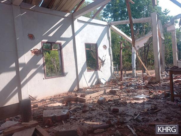
The photos were taken in March 2025 in Aq--- village, A’Kyoo village tract, Kaw T’Ree Township, Dooplaya District. On March 5th 2025, the SAC conducted an air strike in Aq--- village, injuring two villagers and damaging three villagers’ houses. The two villagers sustained minor injuries on their legs. The photos show the damaged villagers’ houses. [Photos: KHRG]
Photo Set: Burma Army air strikes resulting in casualties, destruction, displacement, and contamination in 2025
Since 2021, the Burma military regime[1] has increasingly used air strikes in Southeast Burma, resulting in widespread civilian deaths and injuries, destruction, and displacement. Based on KHRG documentation, in 2025, the Burma Army used different types of weapons, including machine guns, mortars, and various bombs, when conducting deadly air strikes on communities in the seven districts of locally-defined Karen State[2]: Doo Tha Htoo (Thaton), Taw Oo (Toungoo), Kler Lwee Htoo (Nyaunglebin), Mergui-Tavoy, Mu Traw (Hpapun), Dooplaya, and Hpa-an districts.[3] Air attacks were conducted with or without active fighting near villages, without warning or other precautionary measures before the attack.[4] Often, air strikes followed air reconnaissance. A high number of air strikes impacted community buildings, such as schools, monastery compounds, and churches, which are often clearly identifiable from the air, as well as villagers’ homes, farms, and plantations.
This Photo Set includes 83 photos (selected from a total of 3,662 photographs received in 2025), providing evidence of impacts faced by local villagers in the aftermath of Burma Army air strikes in Southeast Burma. 74 of the included photographs were taken by local community members trained by KHRG to monitor human rights conditions in their areas, and nine were taken by local villagers and authorities. The photos show casualties, destruction, displacement, and the different types of weapons used by the Burma Army during air attacks. The names of the victims, their photos, and the exact locations are censored for security and sensitivity reasons.
Further background reading on the situation of air strikes in Southeast Burma/Myanmar can be found in the following KHRG reports:
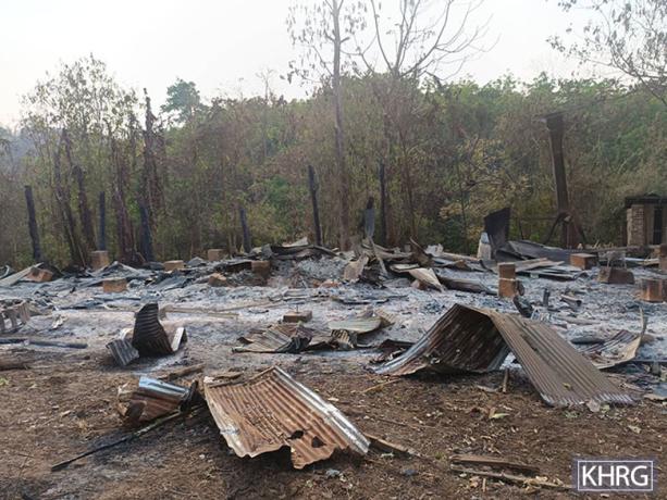 ,
, 
These photos were taken in March 2025 in Ar--- village, Noh Hpoh village tract, Kaw T’Ree Township, Dooplaya District. On March 19th 2025, at around 11 am, an SAC fighter jet carried out an air strike on Ar--- village. The SAC fighter jet dropped two bombs on the village, which landed near a villager’s house, killing two villagers. One of the villagers was severely injured by bomb fragments and was barely recognisable. Both victims had young children and were the breadwinners of their families, so their deaths caused hardships and livelihood challenges. The house near where the bombs landed was destroyed by fire, and its owners were unable to retrieve any belongings. A building near the house was also damaged during the incident. According to villagers, the SAC intentionally targeted villagers, as there were no armed forces present in the village at the time of the attack and no prior fighting had occurred in the area. After the attack, villagers expressed concerns and worries about their security. The photo on the left shows the villager’s house destroyed by the fire as a result of the bomb explosion from the SAC air strike on March 19th 2025. The photo on the right shows a damaged building located near the destroyed house. [Photos: KHRG]
Photo Set: Burma Army air strikes resulting in casualties, destruction, displacement, and contamination in 2025
Since 2021, the Burma military regime[1] has increasingly used air strikes in Southeast Burma, resulting in widespread civilian deaths and injuries, destruction, and displacement. Based on KHRG documentation, in 2025, the Burma Army used different types of weapons, including machine guns, mortars, and various bombs, when conducting deadly air strikes on communities in the seven districts of locally-defined Karen State[2]: Doo Tha Htoo (Thaton), Taw Oo (Toungoo), Kler Lwee Htoo (Nyaunglebin), Mergui-Tavoy, Mu Traw (Hpapun), Dooplaya, and Hpa-an districts.[3] Air attacks were conducted with or without active fighting near villages, without warning or other precautionary measures before the attack.[4] Often, air strikes followed air reconnaissance. A high number of air strikes impacted community buildings, such as schools, monastery compounds, and churches, which are often clearly identifiable from the air, as well as villagers’ homes, farms, and plantations.
This Photo Set includes 83 photos (selected from a total of 3,662 photographs received in 2025), providing evidence of impacts faced by local villagers in the aftermath of Burma Army air strikes in Southeast Burma. 74 of the included photographs were taken by local community members trained by KHRG to monitor human rights conditions in their areas, and nine were taken by local villagers and authorities. The photos show casualties, destruction, displacement, and the different types of weapons used by the Burma Army during air attacks. The names of the victims, their photos, and the exact locations are censored for security and sensitivity reasons.
Further background reading on the situation of air strikes in Southeast Burma/Myanmar can be found in the following KHRG reports:
 ,
, 
These photos were taken by a KHRG researcher in May 2025 in As--- village, Wa Ka village tract, Kruh Tuh Township, Dooplaya District. On April 23rd 2025, at 8:06 pm, the SAC dropped three bombs onto Bq--- village, injuring a villager. Two of the bombs landed on the school campus, close to the teachers’ quarters. One of the bombs exploded, and another bomb remained unexploded on the campus. The exploded bomb destroyed the school, the teachers’ quarters, the school toilets, and the school’s water tank, and damaged another two school buildings and some villagers’ houses. As--- school was under the administration of the SAC. Villagers from As--- village told KHRG that they assumed that the SAC was targeting three buildings during this air strike: the teacher’s quarters in the school campus; a KNU office, located in the village; and As---’s hospital, next to the school. A group of displaced villagers had recently come to stay at the school campus, and so local villagers believed that the SAC might have mistakenly thought they were related to armed resistance forces. Villagers also believed the hospital was targeted because fighting had happened close to the village, and the SAC had assumed that the armed resistance forces were being treated at the hospital. After the attack, fear was widespread. The left photo shows the school’s teacher’s quarters, and the photo on the right shows the destruction of the As--- school, both destroyed by the SAC air strike on April 23rd 2025 on the village.[34] [Photos: KHRG]
Photo Set: Burma Army air strikes resulting in casualties, destruction, displacement, and contamination in 2025
Since 2021, the Burma military regime[1] has increasingly used air strikes in Southeast Burma, resulting in widespread civilian deaths and injuries, destruction, and displacement. Based on KHRG documentation, in 2025, the Burma Army used different types of weapons, including machine guns, mortars, and various bombs, when conducting deadly air strikes on communities in the seven districts of locally-defined Karen State[2]: Doo Tha Htoo (Thaton), Taw Oo (Toungoo), Kler Lwee Htoo (Nyaunglebin), Mergui-Tavoy, Mu Traw (Hpapun), Dooplaya, and Hpa-an districts.[3] Air attacks were conducted with or without active fighting near villages, without warning or other precautionary measures before the attack.[4] Often, air strikes followed air reconnaissance. A high number of air strikes impacted community buildings, such as schools, monastery compounds, and churches, which are often clearly identifiable from the air, as well as villagers’ homes, farms, and plantations.
This Photo Set includes 83 photos (selected from a total of 3,662 photographs received in 2025), providing evidence of impacts faced by local villagers in the aftermath of Burma Army air strikes in Southeast Burma. 74 of the included photographs were taken by local community members trained by KHRG to monitor human rights conditions in their areas, and nine were taken by local villagers and authorities. The photos show casualties, destruction, displacement, and the different types of weapons used by the Burma Army during air attacks. The names of the victims, their photos, and the exact locations are censored for security and sensitivity reasons.
Further background reading on the situation of air strikes in Southeast Burma/Myanmar can be found in the following KHRG reports:
 ,
, 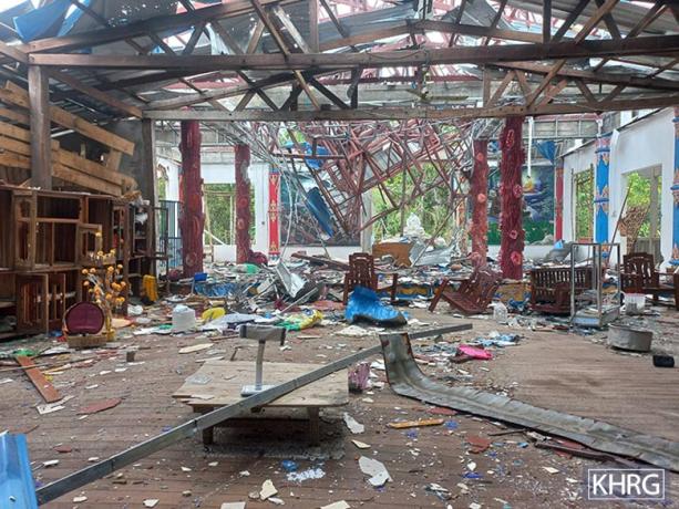
These photos were taken in April 2025 in At--- village, Noh Su Net village tract, Waw Ray Township, Dooplaya District. On March 25th 2025, an SAC fighter jet dropped two 500-pound bombs onto a monastery compound in At--- village while fighting between SAC soldiers and KNLA soldiers was taking place. The air strike injured two monks and six villagers, including a child, and destroyed multiple monastery buildings. The photos show the destroyed village monastery building and a Buddha statue. After the incident, villagers and monks fled from the village for their safety. [Photos: KHRG]
Photo Set: Burma Army air strikes resulting in casualties, destruction, displacement, and contamination in 2025
Since 2021, the Burma military regime[1] has increasingly used air strikes in Southeast Burma, resulting in widespread civilian deaths and injuries, destruction, and displacement. Based on KHRG documentation, in 2025, the Burma Army used different types of weapons, including machine guns, mortars, and various bombs, when conducting deadly air strikes on communities in the seven districts of locally-defined Karen State[2]: Doo Tha Htoo (Thaton), Taw Oo (Toungoo), Kler Lwee Htoo (Nyaunglebin), Mergui-Tavoy, Mu Traw (Hpapun), Dooplaya, and Hpa-an districts.[3] Air attacks were conducted with or without active fighting near villages, without warning or other precautionary measures before the attack.[4] Often, air strikes followed air reconnaissance. A high number of air strikes impacted community buildings, such as schools, monastery compounds, and churches, which are often clearly identifiable from the air, as well as villagers’ homes, farms, and plantations.
This Photo Set includes 83 photos (selected from a total of 3,662 photographs received in 2025), providing evidence of impacts faced by local villagers in the aftermath of Burma Army air strikes in Southeast Burma. 74 of the included photographs were taken by local community members trained by KHRG to monitor human rights conditions in their areas, and nine were taken by local villagers and authorities. The photos show casualties, destruction, displacement, and the different types of weapons used by the Burma Army during air attacks. The names of the victims, their photos, and the exact locations are censored for security and sensitivity reasons.
Further background reading on the situation of air strikes in Southeast Burma/Myanmar can be found in the following KHRG reports:
 ,
, 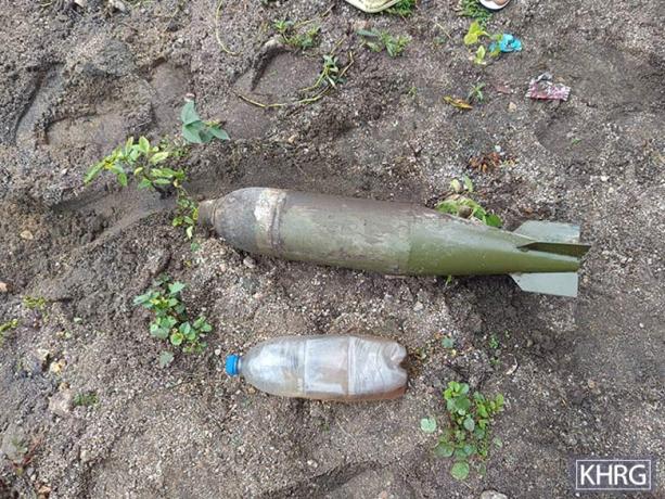
These photos were taken in May 2025 in Au--- village, Thay Baw Boh village tract, Kaw T’Ree Township, Dooplaya District. On May 29th 2025, an SAC fighter jet came and dropped multiple bombs on Au--- village, including at least two 250-pound bombs, despite the absence of fighting in the village. Bombs landed inside a school’s compound in the village, and one remained unexploded. The air strike damaged the school building. This school is administered by the KECD. The explosions also damaged four houses. The photos show the unexploded bomb dropped by the SAC fighter jet. [Photos: KHRG]
Photo Set: Burma Army air strikes resulting in casualties, destruction, displacement, and contamination in 2025
Since 2021, the Burma military regime[1] has increasingly used air strikes in Southeast Burma, resulting in widespread civilian deaths and injuries, destruction, and displacement. Based on KHRG documentation, in 2025, the Burma Army used different types of weapons, including machine guns, mortars, and various bombs, when conducting deadly air strikes on communities in the seven districts of locally-defined Karen State[2]: Doo Tha Htoo (Thaton), Taw Oo (Toungoo), Kler Lwee Htoo (Nyaunglebin), Mergui-Tavoy, Mu Traw (Hpapun), Dooplaya, and Hpa-an districts.[3] Air attacks were conducted with or without active fighting near villages, without warning or other precautionary measures before the attack.[4] Often, air strikes followed air reconnaissance. A high number of air strikes impacted community buildings, such as schools, monastery compounds, and churches, which are often clearly identifiable from the air, as well as villagers’ homes, farms, and plantations.
This Photo Set includes 83 photos (selected from a total of 3,662 photographs received in 2025), providing evidence of impacts faced by local villagers in the aftermath of Burma Army air strikes in Southeast Burma. 74 of the included photographs were taken by local community members trained by KHRG to monitor human rights conditions in their areas, and nine were taken by local villagers and authorities. The photos show casualties, destruction, displacement, and the different types of weapons used by the Burma Army during air attacks. The names of the victims, their photos, and the exact locations are censored for security and sensitivity reasons.
Further background reading on the situation of air strikes in Southeast Burma/Myanmar can be found in the following KHRG reports:
 ,
,  ,
, 
These photos were taken in June 2025 in Av--- village, Paing Ya village tract, Kruh Tuh Township, Dooplaya District. On June 9th 2025, at 1:45 pm, an SAC fighter jet dropped multiple 500-pound bombs and various types of small mortar shells, while a helicopter fired machine guns at Av--- village. As one of the bombs landed on the house in the village where students were studying, the air strike killed three students, one teacher, and one villager. It also injured at least 29 people, including 24 students, one 4-year-old child, and four villagers. The air strikes also damaged at least 12 houses owned by villagers. After the attack, villagers with serious injuries sought treatment in Hpa-an and Mawlamyine towns, while those with less severe injuries were treated in nearby villages. Due to security concerns raised by local village leaders before the attack, the self-funded middle school with around 90 students closed down. Teachers had instructed students to secretly study in villagers’ houses before the attack. The two photos on the top row show villagers’ houses, damaged by the SAC air strike in Av--- village on June 9th 2025. The left photo in the bottom row shows a bottle of water, owned by a student, remaining in the incident place.[35] [Photos: KHRG]
Photo Set: Burma Army air strikes resulting in casualties, destruction, displacement, and contamination in 2025
Since 2021, the Burma military regime[1] has increasingly used air strikes in Southeast Burma, resulting in widespread civilian deaths and injuries, destruction, and displacement. Based on KHRG documentation, in 2025, the Burma Army used different types of weapons, including machine guns, mortars, and various bombs, when conducting deadly air strikes on communities in the seven districts of locally-defined Karen State[2]: Doo Tha Htoo (Thaton), Taw Oo (Toungoo), Kler Lwee Htoo (Nyaunglebin), Mergui-Tavoy, Mu Traw (Hpapun), Dooplaya, and Hpa-an districts.[3] Air attacks were conducted with or without active fighting near villages, without warning or other precautionary measures before the attack.[4] Often, air strikes followed air reconnaissance. A high number of air strikes impacted community buildings, such as schools, monastery compounds, and churches, which are often clearly identifiable from the air, as well as villagers’ homes, farms, and plantations.
This Photo Set includes 83 photos (selected from a total of 3,662 photographs received in 2025), providing evidence of impacts faced by local villagers in the aftermath of Burma Army air strikes in Southeast Burma. 74 of the included photographs were taken by local community members trained by KHRG to monitor human rights conditions in their areas, and nine were taken by local villagers and authorities. The photos show casualties, destruction, displacement, and the different types of weapons used by the Burma Army during air attacks. The names of the victims, their photos, and the exact locations are censored for security and sensitivity reasons.
Further background reading on the situation of air strikes in Southeast Burma/Myanmar can be found in the following KHRG reports:
 ,
,  ,
,  ,
, 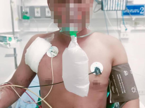
KHRG received these photos from a local villager in July 2025. On July 5th 2025, the Burma Army carried out an air strike on Aw--- village, Maw Hkee village tract, Kaw T’Ree Township, Dooplaya District. The air strike severely injured four villagers, including a child, and they were sent to a hospital in Ax--- Town, in Thailand’s Tak province, for medical treatment. According to a local villager, there was no fighting near the village where the air strike happened. The photos show the four injured villagers receiving medical treatment in Ax--- hospital. [Photos: Local villager]
Photo Set: Burma Army air strikes resulting in casualties, destruction, displacement, and contamination in 2025
Since 2021, the Burma military regime[1] has increasingly used air strikes in Southeast Burma, resulting in widespread civilian deaths and injuries, destruction, and displacement. Based on KHRG documentation, in 2025, the Burma Army used different types of weapons, including machine guns, mortars, and various bombs, when conducting deadly air strikes on communities in the seven districts of locally-defined Karen State[2]: Doo Tha Htoo (Thaton), Taw Oo (Toungoo), Kler Lwee Htoo (Nyaunglebin), Mergui-Tavoy, Mu Traw (Hpapun), Dooplaya, and Hpa-an districts.[3] Air attacks were conducted with or without active fighting near villages, without warning or other precautionary measures before the attack.[4] Often, air strikes followed air reconnaissance. A high number of air strikes impacted community buildings, such as schools, monastery compounds, and churches, which are often clearly identifiable from the air, as well as villagers’ homes, farms, and plantations.
This Photo Set includes 83 photos (selected from a total of 3,662 photographs received in 2025), providing evidence of impacts faced by local villagers in the aftermath of Burma Army air strikes in Southeast Burma. 74 of the included photographs were taken by local community members trained by KHRG to monitor human rights conditions in their areas, and nine were taken by local villagers and authorities. The photos show casualties, destruction, displacement, and the different types of weapons used by the Burma Army during air attacks. The names of the victims, their photos, and the exact locations are censored for security and sensitivity reasons.
Further background reading on the situation of air strikes in Southeast Burma/Myanmar can be found in the following KHRG reports:
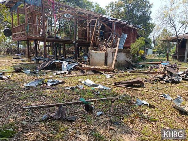
This photo was taken in February 2025 in Ay--- village, Yaw Kuh village tract, T’Nay Hsah Township, Hpa-an District. On February 3rd 2025, SAC Military Operations Command (MOC)[36] #12, based in Hlaing Wa Artillery Unit army camp, Hlaing Wa area, near Kaw T’Ree Town, Kaw T’Ree Township, Dooplaya District, deployed a drone and dropped bombs onto Ay--- village, damaging a villager’s house. The photo shows the heavily damaged house owned by a villager named U Q---. [Photo: KHRG]
Photo Set: Burma Army air strikes resulting in casualties, destruction, displacement, and contamination in 2025
Since 2021, the Burma military regime[1] has increasingly used air strikes in Southeast Burma, resulting in widespread civilian deaths and injuries, destruction, and displacement. Based on KHRG documentation, in 2025, the Burma Army used different types of weapons, including machine guns, mortars, and various bombs, when conducting deadly air strikes on communities in the seven districts of locally-defined Karen State[2]: Doo Tha Htoo (Thaton), Taw Oo (Toungoo), Kler Lwee Htoo (Nyaunglebin), Mergui-Tavoy, Mu Traw (Hpapun), Dooplaya, and Hpa-an districts.[3] Air attacks were conducted with or without active fighting near villages, without warning or other precautionary measures before the attack.[4] Often, air strikes followed air reconnaissance. A high number of air strikes impacted community buildings, such as schools, monastery compounds, and churches, which are often clearly identifiable from the air, as well as villagers’ homes, farms, and plantations.
This Photo Set includes 83 photos (selected from a total of 3,662 photographs received in 2025), providing evidence of impacts faced by local villagers in the aftermath of Burma Army air strikes in Southeast Burma. 74 of the included photographs were taken by local community members trained by KHRG to monitor human rights conditions in their areas, and nine were taken by local villagers and authorities. The photos show casualties, destruction, displacement, and the different types of weapons used by the Burma Army during air attacks. The names of the victims, their photos, and the exact locations are censored for security and sensitivity reasons.
Further background reading on the situation of air strikes in Southeast Burma/Myanmar can be found in the following KHRG reports:
 ,
, 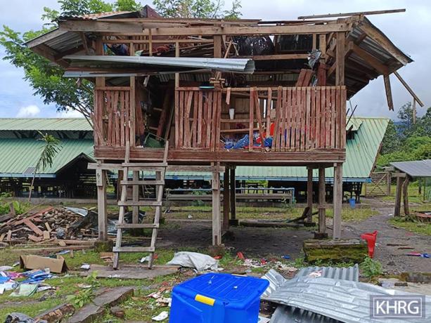
These photos were taken in September 2025 in Az--- village, Pee Ter Hka village tract, Ta Kreh Township, Hpa an District. On September 3rd 2025, at around 9:52 am, the Burma Army used a kamikaze drone and carried out a drone strike on Az--- middle school, in Az--- village. The school is administered by the KECD. The drone attack injured two teachers and a student and damaged a school building. The photo on the left shows an injured student from Bx--- school, and the photo on the right shows a damaged building of the school.[37] [Photos: KHRG]
Photo Set: Burma Army air strikes resulting in casualties, destruction, displacement, and contamination in 2025
Since 2021, the Burma military regime[1] has increasingly used air strikes in Southeast Burma, resulting in widespread civilian deaths and injuries, destruction, and displacement. Based on KHRG documentation, in 2025, the Burma Army used different types of weapons, including machine guns, mortars, and various bombs, when conducting deadly air strikes on communities in the seven districts of locally-defined Karen State[2]: Doo Tha Htoo (Thaton), Taw Oo (Toungoo), Kler Lwee Htoo (Nyaunglebin), Mergui-Tavoy, Mu Traw (Hpapun), Dooplaya, and Hpa-an districts.[3] Air attacks were conducted with or without active fighting near villages, without warning or other precautionary measures before the attack.[4] Often, air strikes followed air reconnaissance. A high number of air strikes impacted community buildings, such as schools, monastery compounds, and churches, which are often clearly identifiable from the air, as well as villagers’ homes, farms, and plantations.
This Photo Set includes 83 photos (selected from a total of 3,662 photographs received in 2025), providing evidence of impacts faced by local villagers in the aftermath of Burma Army air strikes in Southeast Burma. 74 of the included photographs were taken by local community members trained by KHRG to monitor human rights conditions in their areas, and nine were taken by local villagers and authorities. The photos show casualties, destruction, displacement, and the different types of weapons used by the Burma Army during air attacks. The names of the victims, their photos, and the exact locations are censored for security and sensitivity reasons.
Further background reading on the situation of air strikes in Southeast Burma/Myanmar can be found in the following KHRG reports:
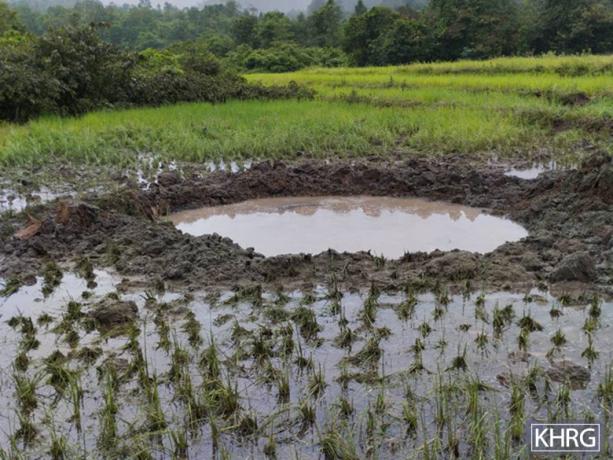
This photo was taken in September 2025 in a rice field near Bc--- village, Htee Wah Blaw village tract, T’Nay Hsa Township, Hpa-an District. On September 10th 2025, a Burma Amy aircraft dropped a bomb on a farm owned by a local villager near Bc--- village. The bomb explosion caused damage to the rice farm. The farm’s owner told KHRG that he was very disappointed about what happened to his farm. [Photo: KHRG]
Photo Set: Burma Army air strikes resulting in casualties, destruction, displacement, and contamination in 2025
Since 2021, the Burma military regime[1] has increasingly used air strikes in Southeast Burma, resulting in widespread civilian deaths and injuries, destruction, and displacement. Based on KHRG documentation, in 2025, the Burma Army used different types of weapons, including machine guns, mortars, and various bombs, when conducting deadly air strikes on communities in the seven districts of locally-defined Karen State[2]: Doo Tha Htoo (Thaton), Taw Oo (Toungoo), Kler Lwee Htoo (Nyaunglebin), Mergui-Tavoy, Mu Traw (Hpapun), Dooplaya, and Hpa-an districts.[3] Air attacks were conducted with or without active fighting near villages, without warning or other precautionary measures before the attack.[4] Often, air strikes followed air reconnaissance. A high number of air strikes impacted community buildings, such as schools, monastery compounds, and churches, which are often clearly identifiable from the air, as well as villagers’ homes, farms, and plantations.
This Photo Set includes 83 photos (selected from a total of 3,662 photographs received in 2025), providing evidence of impacts faced by local villagers in the aftermath of Burma Army air strikes in Southeast Burma. 74 of the included photographs were taken by local community members trained by KHRG to monitor human rights conditions in their areas, and nine were taken by local villagers and authorities. The photos show casualties, destruction, displacement, and the different types of weapons used by the Burma Army during air attacks. The names of the victims, their photos, and the exact locations are censored for security and sensitivity reasons.
Further background reading on the situation of air strikes in Southeast Burma/Myanmar can be found in the following KHRG reports: